A48 autoroute
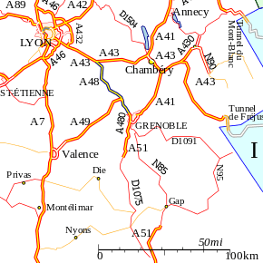
The A48 autoroute, also known as l'autoroute du Dauphiné, is a motorway in France connecting the A43 with the city of Grenoble.
| |
|---|---|
| Autoroute du Dauphiné | |
 | |
| Route information | |
| Part of | |
| Length | 52.5 km (32.6 mi) |
| Existed | 1968–present |
| Major junctions | |
| South end | A43 |
| North end | Grenoble |
| Highway system | |
| Autoroutes of France | |

An extension north to Ambérieu is proposed in the medium term.
Characteristics
- 2x2 lanes
- 2x3 lanes between the A49 and A480 autoroutes (10 km)
- 97 km long
- Service areas
History
- 1968: The first toll free section opened between the Bastille (Grenoble northern edge) and Voreppe as part of the preparations for the Winter Olympics held in the city and surrounding area.
- 1975: Opening of the toll section between Voreppe and the A43 managed by AREA.
Junctions


Autoroute ends.
Places of interest
The following list indexes towns and places of interest that can be visited from the motorway:
- River Isere
- Col de Rossatière
Future
There are proposals to extend the autoroute north from Bourgoin-Jallieu to Ambérieu-in-Bugey and connecting to the A42 autoroute.
External links
- A48 autoroute in Saratlas
 |
| | |
This article is issued from Wikipedia. The text is licensed under Creative Commons - Attribution - Sharealike. Additional terms may apply for the media files.