A42 autoroute

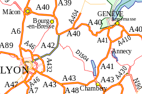
The A42 autoroute is a short motorway in France. Being completed in 1987, the road connects the city of Lyon to its junction with the A40 roughly 50 km north-east of Lyon.

A42 autoroute
Route information
Part of E 611
Length52.3 km (32.5 mi)
Major junctions
North endA40
South endLyon
Highway system
Autoroutes of France

Characteristics

  • 2x2 lanes
  • 2x3 lanes between Lyon and Pérouges (26 km)
  • 70 km long
  • Service areas

History

  • 1983: Section between Neyron and Chazey (30 km) opened
  • 1988: Section between Chazey and Pont-d'Ain (19.5 km) opened

Junctions

  • 01 (Lyon: porte de Croix-Barret) Towns served Lyon Centre, Périphérique (RN383)
  • 01b (Villeurbanne Croix-Luizet-St Jean) Towns served: Villeurbanne Croix-Luizet, St Jean
  • 01a (Vauix-en-Velin) Towns served: Vauix-en-Velin
  • Exchange A42-N346 Junction with N346 Lyon ring road to Orange south.
  • Exchange A42-A46 Junction with A46 part of the Lyon ring road to Paris
  • 04 (Parc de Miribel-Jonage) : Towns served: Neyron and Miribel
  • 05 (Beynost) : Towns served: Beynost
    • Péage de Beynost
  • Exchange A42-A432 Junction with the A432 to Marseille
    • Service Area: Lyon-Dagneux/Lyon-Montluel
  • 06 (Balan-Dagneux) Towns served: Montluel and Balan
  • 07 (Pérouges) Towns served: Pérouges, Meximieux and Saint-Jean-de-Niost
    • Rest Area: Ambérieu
  • 08 (Ambérieu) Towns served: Ambérieu-en-Bugey
  • 09 (Pont-d'Ain) Towns served: Pont-d'Ain
  • Exchange A42-A40 Junction with A40 to Mâcon (north), Geneva (Switzerland) (east) and end of autoroute.

KML is from Wikidata
This article is issued from Wikipedia. The text is licensed under Creative Commons - Attribution - Sharealike. Additional terms may apply for the media files.