'Anata
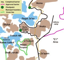
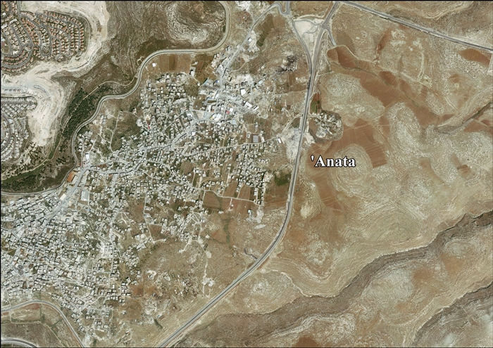
'Anata (Arabic: عناتا) is a Palestinian town in the Jerusalem Governorate in the central West Bank, located four kilometers northeast of Jerusalem's Old City. According to the Palestinian Central Bureau of Statistics, 'Anata had a population of 9,600 in 2006.[4] Its total land area is 30,603 dunams, of which over half now lies within the Israeli Jerusalem municipality and 1,654 is Palestinian built-up area.[5] Since 1967, 'Anata has been occupied by Israel. Together with Shu'afat refugee camp, the village is almost surrounded by the separation barrier, cutting it off from Jerusalem and surrounding villages except for a checkpoint in the west and a road in the north-east that gives access to the rest of the West Bank.[6]
'Anata | |
|---|---|
| Arabic transcription(s) | |
| • Arabic | عناتا |
| • Latin | Anata (official) |
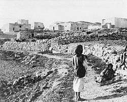
%2C_p._549_in_Thomson%2C_1859.jpg) 'Anata, around 1859[2] | |
 'Anata Location of 'Anata within Palestine | |
| Coordinates: 31°48′46″N 35°15′43″E | |
| Palestine grid | 174/135 |
| State | State of Palestine |
| Governorate | Jerusalem |
| Government | |
| • Type | Village council |
| • Head of Municipality | Ahmad Kamil Alrifai |
| Area | |
| • Total | 30,603 dunams (30.6 km2 or 11.8 sq mi) |
| Population (2006) | |
| • Total | 9,600 |
| • Density | 310/km2 (810/sq mi) |
| Name meaning | Anata, personal name[3] |
History
'Anata is a village on an ancient site, old stones have been reused in village homes, and cisterns dug into rock have been found, together with caves and ancient agricultural terraces.[7]
Bronze and Iron Ages
Edward Robinson identified 'Anata with Biblical Anathoth, birthplace of Jeremiah, in his Biblical researches in Palestine.[8]
Byzantine period
There are ruins of a Byzantine-era church in the town, proving that it was inhabited prior to the Muslim conquest of Palestine by the Rashidun Caliphate in the 7th century.[9][10]
Ayyubid period
Ahead of the 1187 Muslim siege of Jerusalem against the Crusaders, Saladin, the Ayyubid general and sultan, situated his administration in 'Anata before he proceeded towards Jerusalem.[5]
Ottoman period
The village was incorporated into the Ottoman Empire in 1516 with all of Palestine, and in 1596 'Anata appeared in Ottoman tax registers as being in the Nahiya of Quds of the Liwa of Quds. It had a population of 10 Muslim households. The villagers paid a fixed tax rate of 40 % on agricultural products, including wheat, barley, summer crops, olive trees, fruit trees, goats and/or bee hives; a total of 9,300 Akçe. All of the revenue went to a Waqf.[11]
The village was destroyed by Ibrahim Pasha in 1834 following a pro-Ottoman Arab revolt against Egyptian rule.[5] In 1838 Anata was noted as a Muslim village, located north of Jerusalem.[12][8]
When W. M. Thomson visited it in the 1850s, he described it as a "small, half-ruined hamlet, but it was once much larger, and appears to have had a wall around it, a few fragments of which are still to be seen."[13]
In 1863 Victor Guérin visited the village and described it as being a small, situated on a hill, and with 200 inhabitants.[14] Socin found from an official Ottoman village list from about 1870 that 'Anata had 25 houses and a population of 70, though the population count included men, only.[15][16] According to information received by Clermont-Ganneau in 1874, the village was settled by Arab families from Khirbet 'Almit, a mile to the northeast.[9][17]
In 1883, the PEF's Survey of Western Palestine described it as a "village of moderate size, the houses of stone; it stands on a ridge commanding a fine view to the north and east. ...There are a few olives round the village, and a well on the west and another on the south-east."[18]
In 1896 the population of 'Anata was estimated to be about 180 persons.[19]
British Mandate period
In the 1922 census of Palestine conducted by the British Mandate authorities, 'Anata had a population of 285, all Muslim,[20] increasing in the 1931 census to 438, still all Muslim, in 98 houses.[21]
In the 1945 statistics 'Anata had a population of 540 Muslims,[22] with 18,496 dunams of land, according to an official land and population survey.[23] Of this, 353 dunams were plantations and irrigable land, 2,645 used for cereals,[24] while 35 dunams were built-up land.[25]
Jordanian period (1948-1967)
In the wake of the 1948 Arab–Israeli War, 'Anata came under Jordanian rule.
The Jordanian census of 1961 found 852 inhabitants in 'Anata.[26]
Israeli and PA period (1967-current)

After the Six-Day War in 1967, 'Anata has been under Israeli occupation.[27] The population in the 1967 census conducted by the Israeli authorities was 1,260, 121 of whom originated from the Israeli territory.[28]
After the 1995 accords, about 3.8% of the land (or 918 dunams) is classified as being Area B, while the remaining 96.2 % (or 23,108 dunams) is Area C.[29] Most of the lands of 'Anata have been confiscated by Israel.[27] Of the 1877 dunums which remain in residents' hands, after creation of the Palestinian National Authority in 1994, 957 dunums became part of Area B, 220 dunums part of Area C, and 700 dunums have been declared a closed military zone by the Israeli authorities.[27] The Dahyat as-Salam neighbourhood has been annexed by Israel as part of the Jerusalem municipality.[27] The village boundaries are far-reaching and stretch from 'Anata itself to just east of the Israeli settlement of Alon.[30] Most of the land is undeveloped open space with little or no vegetation.[30]
According to the ARIJ, Israel has confiscated land from 'Anata for the construction of 4 Israeli settlements:
- 328 dunams of land were taken for Alon,[31]
- 717 dunams of land were taken for Nofei Prat,[31]
- 820 dunams of land were taken for Kfar Adumim,[31]
- 783 dunams of land were taken for Almon.[31]
Main families
The families are Shiha , Abd al-Latif, Ibrahim, Alayan, Hilwa, Salama, Hamdan, Abu Haniya Musah and al-Kiswani. The latter family fled to 'Anata during the 1948 Arab-Israeli War.[5]
Sanctuaries
'Anata contains two sanctuaries, dedicated to Saleh and possibly Jeremiah. The former is a mosque dedicated to the prophet Saleh (Biblical Shelah), but Saleh's tomb is believed to be in the village of Nabi Salih to the northwest. The latter sanctuary is a cave dedicated to a "Rumia" which according to Charles Simon Clermont-Ganneau, "looks as if it had been connected by the folklore with the name Jeremiah, the initial 'je' being removed by aphaeresis as so frequently happens in Arabic." This signifies that it is very possible that "Rumia" is an Arabicized form of "Jeremiah".[9][17]
Local administration
Before 1996, 'Anata was governed by a mukhtar. Since then a village council was established to govern the town.[5]
References
- Thomson, 1859, vol 2, p. 549
- Thomson, 1859, vol 2, p. 549
- Palmer, 1881, p. 283
- Projected Mid -Year Population for Jerusalem Governorate by Locality 2004- 2006 Palestinian Central Bureau of Statistics.
- 'Anata Town Profile Applied Research Institute - Jerusalem. 21 July 2004.
- Btselem (Nov 2014) Map of the West Bank, Settlements and the Separation Barrier
- Dauphin, 1998, p. 899
- Robinson and Smith, 1841, vol 2, p. 109
- Sharon, 1999, p. 87
- Conder and Kitchener, 1883, SWP III, p. 82
- Hütteroth and Abdulfattah, 1977, p. 117
- Robinson and Smith, 1841, vol 3, Appendix 2, p. 122
- Thomson, 1859, vol 2, p. 548
- Guérin, 1869, p. 76 ff
- Socin, 1879, p. 143
- Hartmann, 1883, p. 127 noted 52 houses
- Clermont-Ganneau, 1896, vol 2, pp. 276-7
- Conder and Kitchener, 1883, SWP III, pp. 7-8
- Schick, 1896, p. 121
- Barron, 1923, Table VII, Sub-district of Jerusalem, p. 14
- Mills,1932, p. 37
- Government of Palestine, Department of Statistics, 1945, p. 24
- Government of Palestine, Department of Statistics. Village Statistics, April, 1945. Quoted in Hadawi, 1970, p. 56
- Government of Palestine, Department of Statistics. Village Statistics, April, 1945. Quoted in Hadawi, 1970, p. 101
- Government of Palestine, Department of Statistics. Village Statistics, April, 1945. Quoted in Hadawi, 1970, p. 151
- Government of Jordan, 1964, p. 23
- "Anata". Grassroots Jerusalem. Retrieved 14 November 2017.
- Perlmann, Joel (November 2011 – February 2012). "The 1967 Census of the West Bank and Gaza Strip: A Digitized Version" (PDF). Levy Economics Institute. Retrieved 24 June 2016.
- 'Anata Town Profile, ARIJ, p. 18
- Land Use/Land Cover Map of 'Anata Village Boundary (Map). Applied Research Institute of Jerusalem. Archived from the original on 2005-12-22. Retrieved 2008-08-06.
- 'Anata Town Profile, ARIJ, p. 19
Bibliography
- Barron, J. B., ed. (1923). Palestine: Report and General Abstracts of the Census of 1922. Government of Palestine.
- Clermont-Ganneau, C.S. (1896). [ARP] Archaeological Researches in Palestine 1873-1874, translated from the French by J. McFarlane. 2. London: Palestine Exploration Fund.
- Conder, C.R.; Kitchener, H. H. (1883). The Survey of Western Palestine: Memoirs of the Topography, Orography, Hydrography, and Archaeology. 3. London: Committee of the Palestine Exploration Fund.
- Dauphin, Claudine (1998). La Palestine byzantine, Peuplement et Populations. BAR International Series 726 (in French). III : Catalogue. Oxford: Archeopress. ISBN 0-860549-05-4.
- Government of Jordan, Department of Statistics (1964). First Census of Population and Housing. Volume I: Final Tables; General Characteristics of the Population (PDF).
- Government of Palestine, Department of Statistics (1945). Village Statistics, April, 1945.
- Guérin, V. (1869). Description Géographique Historique et Archéologique de la Palestine (in French). 1: Judee, pt. 3. Paris: L'Imprimerie Nationale.
- Hadawi, S. (1970). Village Statistics of 1945: A Classification of Land and Area ownership in Palestine. Palestine Liberation Organization Research Centre.
- Hartmann, M. (1883). "Die Ortschaftenliste des Liwa Jerusalem in dem türkischen Staatskalender für Syrien auf das Jahr 1288 der Flucht (1871)". Zeitschrift des Deutschen Palästina-Vereins. 6: 102–149.
- Hütteroth, Wolf-Dieter; Abdulfattah, Kamal (1977). Historical Geography of Palestine, Transjordan and Southern Syria in the Late 16th Century. Erlanger Geographische Arbeiten, Sonderband 5. Erlangen, Germany: Vorstand der Fränkischen Geographischen Gesellschaft. ISBN 3-920405-41-2.
- Mills, E., ed. (1932). Census of Palestine 1931. Population of Villages, Towns and Administrative Areas. Jerusalem: Government of Palestine.
- Palmer, E. H. (1881). The Survey of Western Palestine: Arabic and English Name Lists Collected During the Survey by Lieutenants Conder and Kitchener, R. E. Transliterated and Explained by E.H. Palmer. Committee of the Palestine Exploration Fund.
- Robinson, E.; Smith, E. (1841). Biblical Researches in Palestine, Mount Sinai and Arabia Petraea: A Journal of Travels in the year 1838. 2. Boston: Crocker & Brewster.
- Robinson, E.; Smith, E. (1841). Biblical Researches in Palestine, Mount Sinai and Arabia Petraea: A Journal of Travels in the year 1838. 3. Boston: Crocker & Brewster.
- Schick, C. (1896). "Zur Einwohnerzahl des Bezirks Jerusalem". Zeitschrift des Deutschen Palästina-Vereins. 19: 120–127.
- Sharon, M. (1997). Corpus Inscriptionum Arabicarum Palaestinae, Vol. I, A. BRILL. ISBN 9004108335.
- Socin, A. (1879). "Alphabetisches Verzeichniss von Ortschaften des Paschalik Jerusalem". Zeitschrift des Deutschen Palästina-Vereins. 2: 135–163.
- Thomson, W.M. (1859). The Land and the Book: Or, Biblical Illustrations Drawn from the Manners and Customs, the Scenes and Scenery, of the Holy Land. 2 (1 ed.). New York: Harper & brothers.
External links
- Welcome To 'Anata
- Anata
- Survey of Western Palestine, Map 17: IAA, Wikimedia commons
- 'Anata Town (Fact Sheet), Applied Research Institute–Jerusalem (ARIJ)
- 'Anata Town Profile, ARIJ
- 'Anata aerial photo, ARIJ
- Locality Development Priorities and Needs in 'Anata, ARIJ
Jerusalem Governorate | ||
|---|---|---|
| Cities |  | |
| Municipalities | ||
| Villages | ||
| Refugee camps | ||