Čiovo
Čiovo (pronounced [tʃîɔv̞ɔ]; Italian: Bua) is an island located off the Adriatic coast in Croatia with an area of 28.8 square kilometres (11.1 sq mi) (length 15.3 km (9.5 mi), width up to 3.5 km (2.2 mi)),[1] population of 5,908 inhabitants (2011)[2] and its highest peak is 218 m (Rudine).
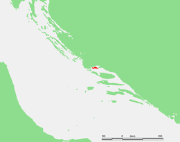
.jpg) Čiovo | |
 | |
| Geography | |
|---|---|
| Location | Adriatic Sea |
| Coordinates | 43°30′N 16°17′E |
| Area | 28.8 km2 (11.1 sq mi) |
| Length | 15.3 km (9.51 mi) |
| Width | 3.5 km (2.17 mi) |
| Highest elevation | 218 m (715 ft) |
| Highest point | Rudine |
| Administration | |
Croatia | |
| County | Split-Dalmatia |
| Demographics | |
| Population | 5,908 (2011) |
The centre of the island has geographical coordinates 43°30′N 16°17′E, and the annual rainfall is about 900 mm (35 in).
Geography
Čiovo is located in central Dalmatia, protecting the town of Trogir and Kaštela gulf. On its SE part it is only two km distant from the cape Marjan, on its northern part it is connected to the mainland with a small bascule bridge in the old centre of Trogir, and actually Trogir spread itself onto the island. Besides the portion of Trogir, on the island there are several villages: Arbanija, Žedno, Okrug Gornji, Okrug Donji, Slatine and Prizidnica.
The vegetation is typically Mediterranean, consisting mainly in understory (holm oak, myrtle, wormwood, juniper etc.). On the northern side (exposed to the wind bura) are forests of pine and cypress. Major crops include olives, figs, almonds, vines and citrus fruit.
Connection to the mainland

Since 1964 the island was connected by a bridge to Trogir which is itself connected to the mainland by another bridge.[3] The development of tourism though generated so much traffic that this connection suffered severe capacity shortages in high season.
A construction of a new bridge which connects Čiovo directly with the mainland began in February 2015. It was opened to traffic on July 17th 2018.[4] The new 546,34 m long bascule bridge is located in about 1 km East the old one.[5][6] Its navigational clearance when spans are closed is 6 metres. [7]
History
In the Middle Ages, Čiovo had many villages and it was a place for lepers. Remains of the pre-Romanesque church of St. Peter have been found near Slatine, in the Supetar cove. The medieval church of St. Maurice (Sv. Mavro) has been preserved in Žedno and the pre-Romanesque church of Our Lady at the Sea (Gospa pokraj mora). The population of Čiovo increased in the 15th century through the settlement of refugees who fled from the Turks.[8] Simultaneously, the suburban areas of Trogir also extended to Čiovo.
References
- Duplančić Leder, Tea; Ujević, Tin; Čala, Mendi (June 2004). "Coastline lengths and areas of islands in the Croatian part of the Adriatic Sea determined from the topographic maps at the scale of 1 : 25 000" (PDF). Geoadria. Zadar. 9 (1): 5–32. doi:10.15291/geoadria.127. Retrieved 2019-12-10.
- Ostroški, Ljiljana, ed. (December 2015). Statistički ljetopis Republike Hrvatske 2015 [Statistical Yearbook of the Republic of Croatia 2015] (PDF). Statistical Yearbook of the Republic of Croatia (in Croatian and English). 47. Zagreb: Croatian Bureau of Statistics. p. 47. ISSN 1333-3305. Retrieved 27 December 2015.
- Gordana Dragan (23 May 2018). "Službeno ime čiovskog mosta izazvalo šok i nevjericu u Trogiru ..." Slobodna Dalmacija.
- D. Gudić (17 July 2018). "Otvoren je novi čiovski most! ..." Slobodna Dalmacija.
- Most Kopno - otok Čiovo (PDF). Hrvatske ceste i Viadukt d.d.
- Jadranka Matić (3 July 2018). "Je li konačno stiže kraj gužvama od Trogira do Čiova? ..." Slobodna Dalmacija.
- J.Radić, Z. Šavor, G. Hrelja Kovačević, N. Mujkanović (2015). Most kopno - otok Čiovo s pristupnim cestama u Trogiru (PDF) (in Croatian). p. 30. ISBN 978-953-6272-78-5.CS1 maint: multiple names: authors list (link)
- Croatia by Robin and Jenny McKelvie