Brač
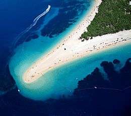
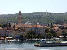
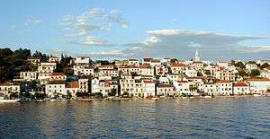
Brač (pronounced [brâːtʃ]; local Chakavian: Broč, pronounced [broːtʃ]; Latin: Bretia, Brattia; Italian: Brazza) is an island in the Adriatic Sea within Croatia, with an area of 396 square kilometres (153 sq mi),[1] making it the largest island in Dalmatia, and the third largest in the Adriatic. It is separated from the mainland by the Brač Channel, which is 5 to 13 km (3 to 8 mi) wide.[2] The island's tallest peak, Vidova gora, or Mount St. Vid, stands at 780 m,[3] making it the highest island point of the Adriatic islands.[4] The island has a population of 13,956,[3] living in numerous settlements, ranging from the main town Supetar, with more than 3,300 inhabitants, to Murvica, where less than two dozen people live. Brač Airport on Brač is the largest airport of all islands surrounding Split.
 | |
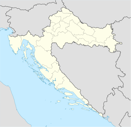 Brač Location of Brač | |
| Geography | |
|---|---|
| Location | Adriatic Sea |
| Coordinates | 43°19′N 16°38′E |
| Archipelago | Dalmatian Archipielago |
| Area | 396 km2 (153 sq mi) |
| Highest elevation | 780 m (2,560 ft) |
| Highest point | Vidova gora |
| Administration | |
Croatia | |
| County | Split-Dalmatia |
| Largest settlement | Supetar (pop. 3,326) |
| Demographics | |
| Population | 13,956 (2011) |
| Pop. density | 35/km2 (91/sq mi) |
| Ethnic groups | Croats |
History
Archaeological findings in the Kopačina cave between Supetar and Donji Humac have been dated to the 12th millennium BC. These are some of the oldest traces of human habitation in Croatia. The findings show that the cave has been inhabited until the 3rd millennium BC (although not continuously). Some of the artefacts have originated in the Dalmatian hinterland, showing that Brač was part of a trade network with the mainland. In the Bronze Age and Iron Age, numerous villages existed.
In the 4th century BC Greek colonisation spread over many Adriatic islands and along the coast, but none of them on Brač. Nevertheless, Greeks visited the island and also traded with the Illyrian inhabitants. The Greek name of the island was Elaphousa, apparently derived from elaphos "stag". Based on this, it has been speculated that the original name of the island may have been derived from Messapic *brentos "stag".[5] Polybius and Plinius record the name of the island as Brattia.[6]
Brač lay on the crossroads of several trade routes from Salona (today Solin) to Issa (today Vis) and the Po River. Greek artifacts were found in the bay of Vičja near Ložišća on the estate of the Rakela-Bugre brothers. Many of the objects belonging to this still unexamined site are now on display in the Archeological Museum of Split.
Dalmatia fell under Roman rule in AD 9. Salona became the capital of the new province and, probably because of its proximity to Salona, significant population centers were present on the island in the Roman period. Signs of Roman habitation are still widespread, but they usually are limited to single Roman villas, cisterns, and especially early quarries between Škrip and Splitska. Splitska also became the most important harbour to carry stone to Salona and the whole of Dalmatia. Diocletian's Palace, which later became Split, was largely built with limestone that was quarried on Brač.[7] Also agriculture, especially wine and olives, began in the same era.
After the destruction of Salona by Avars and Slavs, Brač became a refuge. Tradition has it that Škrip was founded by refugee Salonans, but the town is actually much older than that.
In 872, the island was sacked by Saracen raiders.[8]
From 1268 to 1357 the island recognised the supremacy of the Republic of Venice, and after that they bowed to the Kingdom of Hungary.[9] In the summer of 1390, together with the whole region, they accepted the rule of the Bosnian King Tvrtko Kotromanić, who died the next year.[10] Soon after his death, Hungary claimed the island again. In this whole period, they kept their basic autonomy and old structures - the island was never rich or strategically interesting enough to justify serious intervention. Local nobility administered and ruled Brač and the seat of the council was Nerežišća in the island's center. The leader was selected from the noble families. Only in 1420 did the Venetian Republic reclaim the island, finally sending a representative to assume rule over it.
The Black Death hit Brač from 1434-1436. For 1405, Hranković mentions in his chronicles that Brač has a population of 6,000 - but after the pandemic, only 2,000 people were still living on the island.[11] The population recovered in the following years quickly, with many people moving in from the main land and the population also spreading from the inner parts of the island to the coast, where some of the old pre-Croatian settlements were resettled again. During this time, the Bosnian realm fell to the Ottoman Empire and many refugees settled on the islands, especially on Brač. Many towns were founded in that time and the population began moving from the interior of the island to its coast: to Bol, Milna, Postira, Povlja, Pučišća, Splitska, Sumartin, Supetar i Sutivan. Venice ruled for more than four centuries, until 1797, when the Habsburg Monarchy annexed most of its territory in a deal with Napoleonic France. The official language was Latin.
During the Napoleonic Wars, Brač was conquered by the French Empire for a short time in 1806. In 1807, Prince-Bishop Petar I Njegoš of Montenegro managed to seize Brač with the help of the Russian navy, however already at the Congress of Vienna in 1815 the island was returned to the Austrian Empire. In 1827, the administrative center of Brač moved from Nerežišća to Supetar. Brač was incorporated into the Austrian crownland of Dalmatia from and became a part of Cisleithania of the Monarchy of Austria-Hungary from 1867. After the fall of Austria-Hungary 1918, Brač became part of the Kingdom of Serbs, Croats and Slovenes, or Yugoslavia since 1929. In 1939 an autonomous Croatian Banate was created that included the island.
The population of the island drastically decreased in the beginning of the 20th century due to heavy emigration, mostly to Latin America, especially Argentina and Chile, and to New Zealand and Australia. The emigration continued during the whole century, only later generations preferring to move to European countries, especially Germany. Among others, the Chilean writer Antonio Skármeta is descended from such immigrants.
In 1941 Italian forces occupied the island. In the mountainous regions of the island, native rebels fought a quite effective guerrilla war, but the occupiers answered harshly with arrests and executions. After the Italian capitulation in 1943, German troops occupied the island on January 12 and 13 of 1944, but in July they were defeated and the island was freed.[12] As part of Croatia it became part of the Socialist Federal Republic of Yugoslavia, until Croatia gained its independence in 1991, receiving recognition in 1992. The Croatian War of Independence was barely fought on the island (there was a brief bombing of Milna), but the aftermath of the war, especially the loss in tourism, was disastrous for the island. Only now is the island regenerating from the decade-long drainage of its most important revenue.
Economy
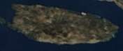
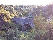
.jpg)
The economy of Brač is based mostly on tourism, but fishing and agriculture (especially wine and olives) are very important too, as is its precious white stone which was used in building Diocletian's Palace in Split and the Canadian National Vimy Memorial.[13] Very widespread is also the claim that it was used in the White House in Washington, D.C.[14] Historically, Brač was famous for goats; even Pliny comments that from the island of Brattia (the Latin name for the island) comes excellent cheese, wine and olive oil.
Administration and settlements
The island is administratively divided into one city and seven municipalities, including the twenty-two settlements. Population numbers are given per 2011 census. The island is part of the Split-Dalmatia County, but is not represented there as a whole, only through its city and municipalities.
The division into eight municipalities and cities happened after the reorganization of Croatia following Croatian independence in 1991. Before that, Brač was a single municipality (općina) in Yugoslavia with Supetar as the seat of the municipality. Still today, many of the administrative duties for the other seven municipalities are delegated to the city of Supetar.
Historically, Nerežišća used to be the administrative and governmental center of the island, and only in 1827 was this role given to Supetar by the Austro-Hungarian administration. The island was divided into 21 cadastral communities by the Austro-Hungarian administration - corresponding to the currently existing settlements besides Ložišća, which was a part of Bobovišća. These cadastral communities were mostly preexisting administrative units and not introduced by the Austro-Hungarians.
Other places of interest are the Blaca hermitage and Drakonjina špilja.

See also
- 10645 Brač, asteroid
Literature
- Prirodne osnove otoka Brača, Bračni zbornik, vol. 14, Ivo Marinković, ed., SIZ za kulturu općine Brač, Supetar, 1984 (in Croatian)
- Povijest otoka Brača, Dasen Vrsalovic, Publisher: Skupština općine Brač, Savjet za prosvjetu i kulturu, Supetar, 1968, OCLC: 8993839 (in Croatian)
- C.Michael Hogan, "Diocletian's Palace", The Megalithic Portal, Andy Burnham ed., Oct. 6, 2007
References
- Duplančić Leder, Tea; Ujević, Tin; Čala, Mendi (June 2004). "Coastline lengths and areas of islands in the Croatian part of the Adriatic Sea determined from the topographic maps at the scale of 1 : 25 000" (PDF). Geoadria. Zadar. 9 (1): 5–32. doi:10.15291/geoadria.127. Retrieved 2019-11-25.
- Brački kanal (in Croatian)
- Ostroški, Ljiljana, ed. (December 2015). Statistički ljetopis Republike Hrvatske 2015 [Statistical Yearbook of the Republic of Croatia 2015] (PDF). Statistical Yearbook of the Republic of Croatia (in Croatian and English). 47. Zagreb: Croatian Bureau of Statistics. p. 47. ISSN 1333-3305. Retrieved 27 December 2015.
- "Brač | island, Croatia". Encyclopedia Britannica. Retrieved 2019-09-18.
- The Messapic word is deduced from a gloss "brendon — elaphon [deer]". The suggestion is due to Anton Mayer (1957), adducing Stephanus De urbibus: "Brettia, insula maris Adriatici habens fluvium Brettium. Hanc Graeci Elaphusam, alii vero Bretanidem appellant", cited after Stanisław Rospond, Slawische Namenkunde: Die slawischen Ortsnamen (1992), p. 162.
- "Island of Brač - Split and Dalmatia County Tourist Board". www.dalmatia.hr. Retrieved 2019-09-18.
- C. Michael Hogan. 2007
- The Italian Cities and the Arabs before 1095, Hilmar C. Krueger, A History of the Crusades: The First Hundred Years, Vol.I, ed. Kenneth Meyer Setton, Marshall W. Baldwin, (University of Pennsylvania Press, 1955), 49.
- "Bol - History of Bol - Discover Bol". www.bol.hr. Retrieved 2019-09-18.
- Naklada Naprijed, The Croatian Adriatic Tourist Guide, pg. 190, Zagreb (1999), ISBN 953-178-097-8
- Šimunović, Petar (1972). Toponomija otoka Brača. Supetar: Skupština općine Brač, Savjet za prosvjetu i kulturu. p. 112.
- Operation "Morgenwind I"
- Fabijančić, Tony; Croatia: Travels in Undiscovered Country p. 127; University of Alberta, 2003 ISBN 0-88864-397-7
- "Yugoslavs Claim Bit Of White House". tribunedigital-sunsentinel. Retrieved 2015-12-05.
External links
| Wikimedia Commons has media related to Island of Brač. |
| Wikisource has the text of the 1911 Encyclopædia Britannica article Brazza. |
