Zorenci
| Zorenci | |
|---|---|
 Zorenci Location in Slovenia | |
| Coordinates: 45°32′21.76″N 15°12′14.26″E / 45.5393778°N 15.2039611°ECoordinates: 45°32′21.76″N 15°12′14.26″E / 45.5393778°N 15.2039611°E | |
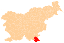
| Country |
|
| Traditional region | White Carniola |
| Statistical region | Southeast Slovenia |
| Municipality | Črnomelj |
| Area | |
| • Total | 3.22 km2 (1.24 sq mi) |
| Elevation | 167.1 m (548.2 ft) |
| Population (2002) | |
| • Total | 36 |
| [1] | |
Zorenci (pronounced [zɔˈɾeːntsi]) is a settlement on the left bank of the Lahinja River south of Črnomelj in the White Carniola area of southeastern Slovenia. The area is part of the traditional region of Lower Carniola and is now included in the Southeast Slovenia Statistical Region.[2]
Name
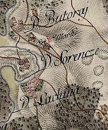
D[orf] Sorencze (i.e., Zorenci) on the First Military Survey Map (1763–1787)
Zorenci was attested in 1463 as Saremcz (and Sorenze in 1744, Sorenzze in 1780, and Sorrenze in 1824). The name Zorenci was created as a folk name from the original local name *Zorenja vas, which is derived from the name Zoren based on the personal name *Zor, Zorislav. Its formation is similar to that of the name Radenci.[3]
History
An archaeological site in the settlement has revealed the presence of an extensive Eneolithic and Bronze Age settlement in the area.[4]
References
- ↑ Statistical Office of the Republic of Slovenia Archived November 18, 2008, at the Wayback Machine.
- ↑ Črnomelj municipal site
- ↑ Torkar, Silvo. "Izvor priimka 'Zore'". Jezikovna svetovalnica. Retrieved July 9, 2018.
- ↑ Slovenian Ministry of Culture register of national heritage Archived July 12, 2010, at the Wayback Machine. reference number ešd 9552
External links

- Zorenci on Geopedia
This article is issued from
Wikipedia.
The text is licensed under Creative Commons - Attribution - Sharealike.
Additional terms may apply for the media files.