Griblje
| Griblje | |
|---|---|
 | |
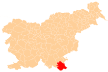
 Griblje Location in Slovenia | |
| Coordinates: 45°34′31.61″N 15°17′33.94″E / 45.5754472°N 15.2927611°ECoordinates: 45°34′31.61″N 15°17′33.94″E / 45.5754472°N 15.2927611°E | |
| Country |
|
| Traditional region | White Carniola |
| Statistical region | Southeast Slovenia |
| Municipality | Črnomelj |
| Area | |
| • Total | 3.4 km2 (1.3 sq mi) |
| Elevation | 153.4 m (503.3 ft) |
| Population (2002) | |
| • Total | 356 |
| [1] | |
Griblje (pronounced [ˈɡɾiːbljɛ]; German: Grüble[2]) is a settlement on the left bank of the Kolpa River in the Municipality of Črnomelj in the White Carniola area of southeastern Slovenia. The area is part of the traditional region of Lower Carniola and is now included in the Southeast Slovenia Statistical Region.[3]
The local church, south of the main settlement, is dedicated to Saint Vitus (Slovene: sveti Vid) and belongs to the Parish of Podzemelj. It was first mentioned in written documents dating to 1526, but the current building dates to the 18th century.[4]
References
- ↑ Statistical Office of the Republic of Slovenia
- ↑ Leksikon občin kraljestev in dežel zastopanih v državnem zboru, vol. 6: Kranjsko. 1906. Vienna: C. Kr. Dvorna in Državna Tiskarna, p. 6.
- ↑ Črnomelj municipal site
- ↑ Slovenian Ministry of Culture register of national heritage reference number ešd 2122
External links
This article is issued from
Wikipedia.
The text is licensed under Creative Commons - Attribution - Sharealike.
Additional terms may apply for the media files.