Zlatá Koruna
| Zlatá Koruna | |||
|---|---|---|---|
| Municipality | |||
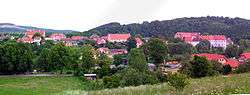 The village seen from the east. Cistercian monastery is visible to the right. | |||
| |||
 Zlatá Koruna | |||
| Coordinates: 48°51′17″N 14°22′10″E / 48.85472°N 14.36944°ECoordinates: 48°51′17″N 14°22′10″E / 48.85472°N 14.36944°E | |||
| Country |
| ||
| Region | South Bohemian | ||
| District | Český Krumlov | ||
| Area | |||
| • Total | 8.81 km2 (3.40 sq mi) | ||
| Elevation | 473 m (1,552 ft) | ||
| Population (2011) | |||
| • Total | 729 | ||
| • Density | 83/km2 (210/sq mi) | ||
| Postal code | 381 01 | ||
| Website | Official website | ||
Zlatá Koruna (German: Goldenkron) is a village and municipality (obec) in Český Krumlov District in the South Bohemian Region of the Czech Republic. The municipality covers an area of 8.81 square kilometres (3.40 sq mi), and has a population of 694 (as at 2005). Zlatá Koruna lies approximately 7 kilometres (4 mi) north-east of Český Krumlov, 16 km (10 mi) south-west of České Budějovice, and 137 km (85 mi) south of Prague.
See also
- 4408 Zlatá Koruna, an asteroid
References
| Wikimedia Commons has media related to Zlatá Koruna. |
This article is issued from
Wikipedia.
The text is licensed under Creative Commons - Attribution - Sharealike.
Additional terms may apply for the media files.