Kájov
| Kájov | |||
|---|---|---|---|
| Municipality | |||
 | |||
| |||
 Kájov | |||
| Coordinates: 48°48′39″N 14°15′31″E / 48.81083°N 14.25861°ECoordinates: 48°48′39″N 14°15′31″E / 48.81083°N 14.25861°E | |||
| Country |
| ||
| Region | South Bohemian | ||
| District | Český Krumlov | ||
| Area | |||
| • Total | 46.43 km2 (17.93 sq mi) | ||
| Elevation | 540 m (1,770 ft) | ||
| Population (2011) | |||
| • Total | 1,647 | ||
| • Density | 35/km2 (92/sq mi) | ||
| Postal code | 382 21 | ||
| Website |
www | ||
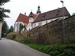
Kájov (German Gojau) is a village and municipality (obec) in Český Krumlov District in the South Bohemian Region of the Czech Republic.
The municipality covers an area of 46.43 square kilometres (17.93 sq mi), and has a population of 1,320 (as at 2005).
Kájov lies approximately 5 kilometres (3 mi) west of Český Krumlov, 25 km (16 mi) south-west of České Budějovice, and 143 km (89 mi) south of Prague.
References
| Wikimedia Commons has media related to Kájov. |
This article is issued from
Wikipedia.
The text is licensed under Creative Commons - Attribution - Sharealike.
Additional terms may apply for the media files.