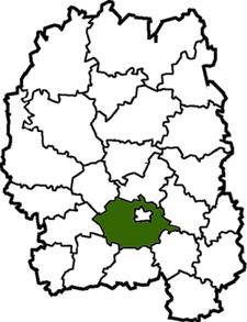
Zhytomyr Raion
| Zhytomyr Raion Житомирський район | |||
|---|---|---|---|
| Raion | |||
| |||
 | |||
| Coordinates: 50°12′17″N 28°38′55″E / 50.20472°N 28.64861°ECoordinates: 50°12′17″N 28°38′55″E / 50.20472°N 28.64861°E | |||
| Country |
| ||
| Region |
| ||
| Admin. center | Zhytomyr | ||
| Subdivisions |
List
| ||
| Area | |||
| • Total | 1,441 km2 (556 sq mi) | ||
| Population (2013) | |||
| • Total |
| ||
| Time zone | UTC+2 (EET) | ||
| • Summer (DST) | UTC+3 (EEST) | ||
| Area code | +380 | ||
Zhytomyr Raion (Ukrainian: Житомирський район) is a raion (district) of Zhytomyr Oblast, northern Ukraine. Its administrative centre is located at Zhytomyr, which however does not belong to the district and is incorporated separately as a city of oblast significance. The raion covers an area of 1,441 square kilometres (556 sq mi). Population: 70,054 (2013 est.)[1]
In 1928-39 the raion was known as Troyaniv Raion centered in a town of Troyaniv (today a small village).
References
- ↑ "Чисельність наявного населення України (Actual population of Ukraine)" (in Ukrainian). State Statistics Service of Ukraine. Retrieved 21 January 2015.
| Raions | |||||
|---|---|---|---|---|---|
| Cities |
| ||||
| |||||
This article is issued from
Wikipedia.
The text is licensed under Creative Commons - Attribution - Sharealike.
Additional terms may apply for the media files.