Zhuhui District
| Zhuhui 珠晖区 | |
|---|---|
| District | |
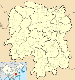
 Zhuhui Location in Hunan | |
| Coordinates: 26°53′41″N 112°37′13″E / 26.8946226698°N 112.6202515032°ECoordinates: 26°53′41″N 112°37′13″E / 26.8946226698°N 112.6202515032°E | |
| Country | People's Republic of China |
| Province | Hunan |
| Prefecture-level city | Hengyang |
| Time zone | UTC+8 (China Standard) |
Zhuhui District (simplified Chinese: 珠晖区; traditional Chinese: 珠暉區; pinyin: Zhūhuī Qū) is an urban district of Hengyang City, Hunan province, China. The district is located in the east of the city proper and on the east shore of Xiang River, it is bordered by Shigu District to the northwest, Yanfeng District to the southwest, Hengnan County to the southeast and the south, Hengyang County to the northeast. Zhuhui District covers 234.03 km2 (90.36 sq mi), as of 2015, it had a permanent resident population of 344,400.[1] The district has 7 subdistricts, 2 townships and a town under its jurisdiction.[2]
References
- ↑ the population of Zhuhui District in 2015, according to the Statistical Communiqué of Zhuhui District on the 2015 National Economic and Social Development (2015年珠晖区国民经济和社会发展统计公报) hengyang.gov
- ↑ the divisions of Zhuhui District in 2015, according to the result on adjustment of township-level administrative divisions of Zhuhui District on November 18, 2015 / 《关于同意珠晖区乡镇区划调整方案的批复》(湘民行发〔2015〕37号) rednet (18-Nov-15), also see people.com : 湖南省乡镇区划调整改革109个县市区批复方案 (2015-12-08) or xinhuanet.com
External links
- www.xzqh.org (in Chinese)
This article is issued from
Wikipedia.
The text is licensed under Creative Commons - Attribution - Sharealike.
Additional terms may apply for the media files.