Zaskar Range
| Zaskar Range | |
|---|---|
| Zanskar Range | |
 | |
| Highest point | |
| Peak | Kamet (Chamoli District of Uttarakhand, India) |
| Elevation | 7,756 m (25,446 ft) |
| Prominence | 2,825 m (9,268 ft) |
| Dimensions | |
| Area | 7,000 km2 (2,700 sq mi) |
| Geography | |
| Location | Jammu and Kashmir and Uttarakhand, India |
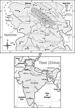

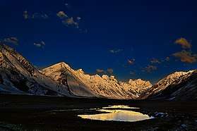
The Zaskar Range or Zanskar Range is a mountain range in the Indian state of Jammu and Kashmir that separates Zanskar from Ladakh.[1] Geologically, the Zanskar Range is part of the Tethys Himalaya, an approximately 100-km-wide synclinorium formed by strongly folded and imbricated, weakly metamorphosed sedimentary series. The average height of the Zanskar Range is about 6,000 m (19,700 ft). Its eastern part is known as Rupshu. It belongs to the trans-Himalayas.[2]
Geography
Zanskar covers an area of some 7,000 square kilometres (2,700 sq mi), at an elevation of 3,500-7,000 metres (11,500–23,000 feet).
The Zaskar River flows through this range and cuts the deep and narrow Zanskar Gorge.
The range extends southeastward for some 400 miles (640 km) from the Karcha (Suru) River to the upper Karnali River. Kamet Peak (25,446 feet [7,756 metres]) is the highest point, and the most important passes are Shipki, Lipu Lekh (Lipulieke), and Mana.[1]
References
- 1 2 "Zaskar Range | mountains, Asia". Encyclopedia Britannica. Retrieved 2017-09-20.
- ↑ http://www.pmfias.com