Zapadnaya Litsa River
| Zapadnaya Litsa (Russian: Западная Лица) | |
| River | |
 | |
| Country | Russia |
|---|---|
| Region | Murmansk Oblast |
| Source | |
| - location | Kuchintundra |
| - elevation | 250 m (820 ft) |
| Mouth | |
| - location | Paatsjoki |
| Length | 107 km (66 mi) |
| Basin | 1,190 km2 (459 sq mi) |
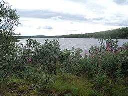
Zapadnaya Litsa River (Russian: Западная Лица ; German: Sapadnaja Liza) is a river in the north of the Kola Peninsula in Murmansk Oblast, Russia. It is 107 km in length. The area of its basin is 1,190 km². The Zapadnaya Litsa River originates on the Kuchintundra and flows into the Barents Sea. Its biggest tributary is the Lebyazhka River.
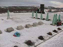
From 1941 to 1944, the Litsa River formed the Arctic frontline between German and Finnish troops west of the river – trying to capture Murmansk – and Soviet troops on the east, defending the city. This frontier was of vital importance for both sides, as Murmansk was the only Soviet harbour left in Europe and the northern route to Murmansk and Arkhangelsk supplied the Soviet Union with approximately 25% of all lend-lease aid.[1] During the stalemate that lasted four years, thousands perished in the tundras on both sides of the river. At the time the Litsa valley was called Death Valley (Долина смерти, Dolina smerti) by the Soviets; though later the expression Valley of Honor (Долина славы, Dolina slavy) became fashionable. The defense of Murmansk succeeded; the Germans never reached the city and the supply lines were not seriously interrupted, although the Germans bombed Murmansk to rubble from occupied Norway. See also: Operation Silver Fox and Operation Platinum Fox. The remains of the WW II fighting (trenches, pillboxes, defense pits etc.) can be visited with some specialised travel agencies.[2][3]
Memorial for the Defenders of the Soviet Arctic on Litsa River (images)
 Grave with helmet and flowers
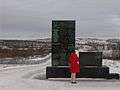 Memorial No. 1
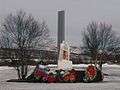 Memorial No. 2
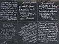 Messages by fallen soldiers
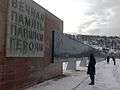 List of names of the fallen
References
- ↑ http://www.feldgrau.com/econo.html Of all the lend-lease aid, approximately 50% was delivered via the Pacific, 25% via Persia and 25% via the northern route to Archangel and Murmansk.
- ↑ "Archived copy". Archived from the original on July 20, 2011. Retrieved September 6, 2010.
- ↑ "Archived copy". Archived from the original on November 7, 2010. Retrieved September 6, 2010.
Coordinates: 69°25′37″N 32°16′50″E / 69.42694°N 32.28056°E