Murmansk Oblast
| Murmansk Oblast Мурманская область (Russian) | |||||
|---|---|---|---|---|---|
| — Oblast — | |||||
| |||||
| |||||
|
| |||||
| Political status | |||||
| Country | Russia | ||||
| Federal district | Northwestern[1] | ||||
| Economic region | Northern[2] | ||||
| Established | May 28, 1938[3] | ||||
| Oblast day | May 28[4] | ||||
| Administrative center | Murmansk[5] | ||||
| Government (as of April 2014) | |||||
| • Governor[6] | Marina Kovtun[7] | ||||
| • Legislature | Oblast Duma[8] | ||||
| Statistics | |||||
| Area (as of the 2002 Census)[9] | |||||
| • Total | 144,900 km2 (55,900 sq mi) | ||||
| Area rank | 26th | ||||
| Population (2010 Census)[10] | |||||
| • Total | 795,409 | ||||
| • Rank | 62nd | ||||
| • Density[11] | 5.49/km2 (14.2/sq mi) | ||||
| • Urban | 92.8% | ||||
| • Rural | 7.2% | ||||
| Population (January 2014 est.) | |||||
| • Total | 771,100[12] | ||||
| Time zone(s) | MSK (UTC+03:00)[13] | ||||
| ISO 3166-2 | RU-MUR | ||||
| License plates | 51 | ||||
| Official languages | Russian[14] | ||||
| Official website | |||||

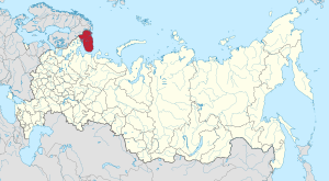
Murmansk Oblast (Russian: Му́рманская о́бласть, tr. Murmanskaya oblast, IPA: [ˈmurmənskəjə ˈobləsʲtʲ]) is a federal subject (an oblast) of Russia, located in the northwestern part of the country. Its administrative center is the city of Murmansk. As of the 2010 Census, its population was 795,409.[10]
Geography
Geographically, Murmansk Oblast is located mainly on the Kola Peninsula almost completely north of the Arctic Circle[15] and is a part of the larger Lapland region that spans over four countries.[16] The oblast borders with the Republic of Karelia in Russia in the south, Lapland Region in Finland in the west, Finnmark County in Norway in the northwest, and is washed by the Barents Sea in the north and the White Sea in the south and east.[15] Arkhangelsk Oblast of Russia lies across the White Sea.[15]
Much of the oblast's relief is hilly, with the Khibiny and Lovozero ranges rising as high as 1,200 meters (3,900 ft) above sea level and stretching from west to east.[15] The north of the oblast is mostly covered by tundra; forest tundra prevails further south, while the southern regions are in the taiga zone.[15] There are over 100,000 lakes and 18,000 rivers in the oblast.[15] The coast contains the Rybachy Peninsula and the Cape Svyatoy Nos peninsulas.
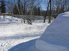
The climate is harsh and unstable, due to the proximity of the Gulf Stream on one side and Arctic cold fronts on the other.[15] Sharp temperature changes, high winds, and abundant precipitation are common throughout the year, with the heating season lasting for ten straight months.[15] However, the waters of the Murman Coast in the south remain warm enough to remain ice-free even in winter.[17]
There is also a large number of islands belonging to the oblast, the main ones being (west to east) the Aynovy Islands, Bolshoy Oleny Island, Kildin Island Malyy Oleniy Island, Kharlov Island, Vesknyak Island, Litskiye Island, Nokuyev Island, Vitte Island, Lumbovskiy Island, Goryainov Island and Sosnovets Island.
History
The Saami, now a very small minority, are the indigenous people of the region. However, Russians started exploring the shores of the White Sea as early as in the 12th century. Despite these early settlements the city of Murmansk was only being founded in 1916.
The oblast was established on May 28, 1938 from Murmansk Okrug of Leningrad Oblast (comprising the city of Murmansk, Kirovsky, Kolsky, Lovozersky, Polyarny, Saamsky, Teribersky, and Tersky Districts) and Kandalakshsky District of the Karelian ASSR.[3]
The area of Pechengsky District (Petsamo in Finnish), which was ceded to Finland by the 1920 Treaty of Tartu and gave Finland access to the Barents Sea, was recaptured by the Soviet Union in 1940. After the Paris Peace Treaties of 1947, the local Saami population was given the choice either of staying in Soviet Russia or resettling in Finland. Most of them chose the second option.
Politics

During the Soviet period, the high authority in the oblast was shared between three persons: The first secretary of the Murmansk CPSU Committee (who in reality had the biggest authority), the chairman of the oblast Soviet (legislative power), and the Chairman of the oblast Executive Committee (executive power). Since 1991, CPSU lost all the power, and the head of the Oblast administration, and eventually the governor was appointed/elected alongside elected regional parliament.
The Charter of Murmansk Oblast is the fundamental law of the region. The Legislative Assembly of Murmansk Oblast is the province's standing legislative (representative) body. The Legislative Assembly exercises its authority by passing laws, resolutions, and other legal acts and by supervising the implementation and observance of the laws and other legal acts passed by it. The highest executive body is the Oblast Government, which includes territorial executive bodies such as district administrations, committees, and commissions that facilitate development and run the day to day matters of the province. The Oblast administration supports the activities of the Governor who is the highest official and acts as guarantor of the observance of the oblast Charter in accordance with the Constitution of Russia.
Governors of Murmansk Oblast
| Name | Period |
|---|---|
| Yury Yevdokimov | December 1997 – March 21, 2009 |
| Dmitry Dmitriyenko | March 21, 2009 – April 4, 2012 |
| Marina Kovtun | April 4, 2012 - incumbent |
Chairmen of the Murmansk Oblast Duma
| Name | Period |
|---|---|
| Pavel Sazhinov | 1994 – 2007 |
| Yevgeny Nikora | 2007 – 2011 |
| Vasily Shambir | 2011 – 2014 |
| Mikhail Ilinykh | 2014 – Incumbent |
Source:[18]
Administrative divisions
Demographics
Population: 795,409 (2010 Census);[10] 892,534 (2002 Census);[19] 1,146,757 (1989 Census).[20]
The indigenous people of the area, the Saami, are only a tiny minority today. As of the 2002 Census, 92.2% of the oblast's population live in urban areas.[21] The most populous city is the Oblast's administrative center, Murmansk, with 336,137 inhabitants.[21] Other large cities and towns include Severomorsk, Apatity, Kandalaksha, Monchegorsk, and Kirovsk.
According to the 2010 Census, the ethnic composition of the oblast was as follows:[10]
- Russians: 89%
- Ukrainians: 4.8%
- Belarusians: 1.7%
- Tatars: 0.8%
- Azeris: 0.5%
- Mordvins: 0.2%
- Karelians: 0.2%
- Komi: 0.2%
- Saami: 0.2%
- others: 2.4%
- 73,484 people were registered from administrative databases, and could not declare an ethnicity. It is estimated that the proportion of ethnicities in this group is the same as that of the declared group.[22]
- Birth rate: 11.7 per 1000 (average for Russia is 13.30)
- Death rate: 11.2 per 1000[23]
- Total fertility rate:[24]
In 2009, the urban areas were marked by natural population decline (-0.16% per year) and the rural areas were marked by natural population growth (+0.35% per year).[25]
Religion
According to a 2012 survey[26] 41.7% of the population of Murmansk Oblast adheres to the Russian Orthodox Church, 3% are unaffiliated generic Christians, 1% are Orthodox Christian believers who do not belong to any church or are members of other (non-Russian) Orthodox churches, 1% are adherents of Islam, 0.4% are adherents of Rodnovery (Slavic native faith) and other indigenous folk religions, and 1% are members of the Catholic Church. In addition, 28% of the population declares to be "spiritual but not religious", 12% is atheist, and 12.5% follows other religions or did not give an answer to the question.[26]
Economy
The Murmansk Oblast is very rich in natural resources and has deposits of over 700 minerals.[28] The main industries of the region are in the sphere of raw material extraction and basic processing.[29] The largest industries are metallurgy (36,6%), electric power-production (22,9%) and food-industry, including fishing (13,7%).[30][31] The icefree port of Murmansk plays an important role in marine transportation in Russia, and the oblast has a 41% share of the total Russian marine transport market.[32][33] The fishing industry is among the most profitable in the region, supplying 16% of Russia's total fish production. Murmansk is a key base for three fishing fleets, including Russia's largest, the Murmansk Trawl Fleet.[29]
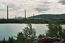
The economy of the region is export-oriented. Main export items are nickel products, apatite concentrate, copper and copper products, aluminium and ferrous metals.[32] The Murmansk Region produces almost 100 percent of Russia's apatite concentrate (3.7 million tons in 1998), 43 percent of nickel, 15 percent of copper, 12 percent of iron ore and iron ore concentrate (17.7 million and 6.4 million tons in 1998), and 40 percent of cobalt.[28][30]
The largest companies of the region – constituting 90% of the oblast's production – are Pechenganickel, Olcon, the Kola Nuclear Power Plant, Sevrybkholodflot, Murmanrybprom, Murmansk Trawl Fleet and Murmansk Shipping Company.[28]
Large oil and gas resources have been discovered on the shelf of the Barents sea, including the massive Shtokman field - one of the world's largest gas fields with estimated reserves of 3.8 trillion cubic meters.[28][33][34] Prospective oil fields could potentially yield up to 40 million tons in the next 10–15 years.[28] However, the development of the oil and gas resources will require considerable investment.[28]
In 2006, the Murmansk Oblast's gross regional product was 141.9 billion rubles, which amounts to about 0.4% of the Russian GDP.[32] Unemployment in 2006 was 3,4%.[32] GRP pro capita in 2007 was 225 044 rubles.[35] Regional automobile code is 51.
Transportation
- Airports in Murmansk (international), Kirovsk, Kandalaksha, Severomorsk (military), Lovozero, Ponoy, and Krasnoshchelye (small planes and choppers)
- Strategic Oktyabrskaya Railway which connects Murmansk with Saint-Petersburg and central Russia. Main stations are Murmansk, Olenegorsk, Kandalaksha. There is also important shoulder to Nikel, the Murmansk-Nikel Railway.
- Local one-way railways
- Sea routes to small military towns and naval bases on Murman Coast (Ostrovnoy, Svyatoy Nos).
- Automobile roads
Military
The Murmansk Oblast plays an important role for the Russian Navy, the Northern Fleet having its headquarters in Severomorsk, 25 km north of Murmansk. The Navy has several other bases and shipyards in the Murmansk Oblast.
The 200th Independent Motor Rifle Brigade is stationed at Pechenga (urban-type settlement), Murmansk Oblast.
See also
References
Notes
- ↑ Президент Российской Федерации. Указ №849 от 13 мая 2000 г. «О полномочном представителе Президента Российской Федерации в федеральном округе». Вступил в силу 13 мая 2000 г. Опубликован: "Собрание законодательства РФ", №20, ст. 2112, 15 мая 2000 г. (President of the Russian Federation. Decree #849 of May 13, 2000 On the Plenipotentiary Representative of the President of the Russian Federation in a Federal District. Effective as of May 13, 2000.).
- ↑ Госстандарт Российской Федерации. №ОК 024-95 27 декабря 1995 г. «Общероссийский классификатор экономических регионов. 2. Экономические районы», в ред. Изменения №5/2001 ОКЭР. (Gosstandart of the Russian Federation. #OK 024-95 December 27, 1995 Russian Classification of Economic Regions. 2. Economic Regions, as amended by the Amendment #5/2001 OKER. ).
- 1 2 Decree of May 28, 1938
- ↑ Charter of Murmansk Oblast, Article 3.3
- ↑ Charter of Murmansk Oblast, Article 8.1
- ↑ Charter of Murmansk Oblast, Article 14.1
- ↑ Official website of the Governor of Murmansk Oblast. Marina Vasilyevna Kovtun, Governor of Murmansk Oblast Archived April 8, 2014, at the Wayback Machine. (in Russian)
- ↑ Charter of Murmansk Oblast, Article 13
- ↑ Федеральная служба государственной статистики (Federal State Statistics Service) (2004-05-21). "Территория, число районов, населённых пунктов и сельских администраций по субъектам Российской Федерации (Territory, Number of Districts, Inhabited Localities, and Rural Administration by Federal Subjects of the Russian Federation)". Всероссийская перепись населения 2002 года (All-Russia Population Census of 2002) (in Russian). Federal State Statistics Service. Retrieved 2011-11-01.
- 1 2 3 4 Russian Federal State Statistics Service (2011). "Всероссийская перепись населения 2010 года. Том 1" [2010 All-Russian Population Census, vol. 1]. Всероссийская перепись населения 2010 года (2010 All-Russia Population Census) (in Russian). Federal State Statistics Service. Retrieved June 29, 2012.
- ↑ The density value was calculated by dividing the population reported by the 2010 Census by the area shown in the "Area" field. Please note that this value may not be accurate as the area specified in the infobox is not necessarily reported for the same year as the population.
- ↑ Murmansk Oblast Territorial Branch of the Federal State Statistics Service. "Демография" (PDF). (in Russian)
- ↑ Правительство Российской Федерации. Федеральный закон №107-ФЗ от 3 июня 2011 г. «Об исчислении времени», в ред. Федерального закона №271-ФЗ от 03 июля 2016 г. «О внесении изменений в Федеральный закон "Об исчислении времени"». Вступил в силу по истечении шестидесяти дней после дня официального опубликования (6 августа 2011 г.). Опубликован: "Российская газета", №120, 6 июня 2011 г. (Government of the Russian Federation. Federal Law #107-FZ of June 31, 2011 On Calculating Time, as amended by the Federal Law #271-FZ of July 03, 2016 On Amending Federal Law "On Calculating Time". Effective as of after sixty days following the day of the official publication.).
- ↑ Official throughout the Russian Federation according to Article 68.1 of the Constitution of Russia.
- 1 2 3 4 5 6 7 8 2007 Atlas of Murmansk Oblast, p. 2
- ↑ Ratcliffe, p. 1
- ↑ Field
- ↑ "Мурманская областная Дума. Официальный сайт". murman.ru. Retrieved January 26, 2017.
- ↑ Russian Federal State Statistics Service (May 21, 2004). "Численность населения России, субъектов Российской Федерации в составе федеральных округов, районов, городских поселений, сельских населённых пунктов – районных центров и сельских населённых пунктов с населением 3 тысячи и более человек" [Population of Russia, Its Federal Districts, Federal Subjects, Districts, Urban Localities, Rural Localities—Administrative Centers, and Rural Localities with Population of Over 3,000] (XLS). Всероссийская перепись населения 2002 года [All-Russia Population Census of 2002] (in Russian). Retrieved August 9, 2014.
- ↑ Demoscope Weekly (1989). "Всесоюзная перепись населения 1989 г. Численность наличного населения союзных и автономных республик, автономных областей и округов, краёв, областей, районов, городских поселений и сёл-райцентров" [All Union Population Census of 1989: Present Population of Union and Autonomous Republics, Autonomous Oblasts and Okrugs, Krais, Oblasts, Districts, Urban Settlements, and Villages Serving as District Administrative Centers]. Всесоюзная перепись населения 1989 года [All-Union Population Census of 1989] (in Russian). Институт демографии Национального исследовательского университета: Высшая школа экономики [Institute of Demography at the National Research University: Higher School of Economics]. Retrieved August 9, 2014.
- 1 2 Федеральная служба государственной статистики (Federal State Statistics Service) (2004-05-21). "Численность населения России, субъектов Российской Федерации в составе федеральных округов, районов, городских поселений, сельских населённых пунктов – районных центров и сельских населённых пунктов с населением 3 тысячи и более человек" [Population of Russia, its federal districts, federal subjects, districts, urban localities, rural localities—administrative centers, and rural localities with population of over 3,000]. Всероссийская перепись населения 2002 года (All-Russia Population Census of 2002) (in Russian). Federal State Statistics Service. Retrieved 2009-04-17.
- ↑ "ВПН-2010". perepis-2010.ru. Retrieved January 26, 2017.
- ↑ "Естественное движение населения в разрезе субъектов Российской Федерации". gks.ru. Retrieved January 26, 2017.
- ↑ "Каталог публикаций::Федеральная служба государственной статистики". gks.ru. Retrieved January 26, 2017.
- ↑ "Archived copy". Archived from the original on August 22, 2011. Retrieved April 27, 2011.
- 1 2 3 "Arena: Atlas of Religions and Nationalities in Russia". Sreda, 2012.
- ↑ 2012 Arena Atlas Religion Maps. "Ogonek", № 34 (5243), 27/08/2012. Retrieved 21/04/2017. Archived.
- 1 2 3 4 5 6 "Overview of Murmansk Region". Federation of American Scientists. Retrieved 2009-06-05.
- 1 2 Murmansk Oblast Globalsecurity.org
- 1 2 "Murmansk region". Häme Polytechnic. Archived from the original on July 20, 2011. Retrieved June 5, 2009.
- ↑ "Murmansk Region". Retrieved 2009-06-05.
- 1 2 3 4 "Non-working link message - Barentsinfo". barentsinfo.org. Retrieved January 26, 2017.
- 1 2 Economic Development in the Murmansk Region in 2007
- ↑ "UPDATE 1-Russia's Gazprom ups Shtokman reserves to 3.8 tcm". November 15, 2016. Retrieved January 26, 2017 – via Reuters.
- ↑ Валовой региональный продукт на душу населения Федеральная служба государственной статистики
Sources
- Мурманская областная Дума. Закон от 26 ноября 1997 г. «Устав Мурманской области», в ред. Закона №1448-01-ЗМО от 27 декабря 2011 г. «О внесении изменения в статью 58 Устава Мурманской области». Вступил в силу на двенадцатый день со дня официального опубликования в газете "Мурманский Вестник". Опубликован: "Мурманский Вестник", №235, стр. 6–7, 6 декабря 1997 г. (Murmansk Oblast Duma. Law of November 26, 1997 Charter of Murmansk Oblast, as amended by the Law #1448-01-ZMO of December 27, 2011 On Amending Article 58 of the Charter of Murmansk Oblast. Effective as of the day twelve days after the official publication in the Murmansky Vestnik newspaper.).
- Президиум Верховного Совета СССР. Указ от 28 мая 1938 г. «Об образовании Мурманской области». Опубликован: "Ведомости Верховного Совета СССР", №7, 1938. (Presidium of the Supreme Soviet of the USSR. Decree of May 28, 1938 On Establishing Murmansk Oblast. ).
- Министерство транспорта Российской Федерации. Федеральное агенство геодезии и картографии (2007). Мурманская область. Атлас. Санкт-Петербург: ФГУП "Геодезия".
- Ratcliffe, Derek A. (2005). Lapland: A Natural History. Yale University Press.
- Wm. O. Field, Jr. The Kola Peninsula. Gibraltar of the Western Arctic. The American Quarterly on the Soviet Union. July 1938. Vol. I, No. 2.
External links
| Wikimedia Commons has media related to Murmansk Oblast. |
- Official website of Murmansk Oblast (in Russian)
- Murmansk Oblast news
| |||||||||||||||||
| |||||||||||||||||