Zalaegerszeg District
| Zalaegerszeg District Zalaegerszegi járás | ||
|---|---|---|
| Districts of Hungary | ||
| ||
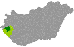 Zalaegerszeg District within Hungary and Zala County. | ||
| Country |
| |
| County | Zala | |
| District seat | Zalaegerszeg | |
| Area | ||
| • Total | 1,044.70 km2 (403.36 sq mi) | |
| Area rank | 1st in Zala | |
| Population (2011 census) | ||
| • Total | 102,798 | |
| • Rank | 1st in Zala | |
| • Density | 98/km2 (250/sq mi) | |
Zalaegerszeg (Hungarian: Zalaegerszegi járás) is a district in northern part of Zala County. Zalaegerszeg is also the name of the town where the district seat is found. The district is located in the Western Transdanubia Statistical Region.
Geography
Zalaegerszeg District borders with Vasvár District (Vas County) to the north, Zalaszentgrót District to the northeast, Keszthely District to the east, Nagykanizsa District and Letenye District to the south, Lenti District to the west, Körmend District (Vas County) to the northwest. The number of the inhabited places in Zalaegerszeg District is 84.
Municipalities
The district has 1 urban county, 2 towns and 81 villages. (ordered by population, as of 1 January 2013)[1]
- Alibánfa (407)
- Almásháza (63)
- Alsónemesapáti (676)
- Babosdöbréte (466)
- Bagod (1,254)
- Bak (1,628)
- Baktüttös (333)
- Becsvölgye (791)
- Bezeréd (141)
- Bocfölde (1,123)
- Boncodfölde (346)
- Böde (296)
- Búcsúszentlászló (811)
- Csatár (550)
- Csertalakos (27)
- Csonkahegyhát (326)
- Csöde (80)
- Dobronhegy (142)
- Egervár (1,051)
- Gellénháza (1,571)
- Gombosszeg (36)
- Gősfa (321)
- Gutorfölde (1,051)
- Gyűrűs (96)
- Hagyárosbörönd (310)
- Hottó (327)
- Iborfia (9)
- Kávás (247)
- Kemendollár (523)
- Keménfa (90)
- Kisbucsa (450)
- Kiskutas (171)
- Kispáli (291)
- Kustánszeg (481)
- Lakhegy (453)
- Lickóvadamos (198)
- Milejszeg (308)
- Misefa (291)
- Nagykapornak (925)
- Nagykutas (422)
- Nagylengyel (509)
- Nagypáli (477)
- Nemesapáti (519)
- Nemeshetés (262)
- Nemesrádó (295)
- Nemessándorháza (302)
- Nemesszentandrás (270)
- Németfalu (190)
- Orbányosfa (126)
- Ormándlak (122)
- Ozmánbük (198)
- Pacsa (1,676)
- Padár (112)
- Pálfiszeg (159)
- Pethőhenye (418)
- Petrikeresztúr (370)
- Pókaszepetk (937)
- Pölöske (842)
- Pusztaederics (166)
- Pusztaszentlászló (598)
- Salomvár (615)
- Sárhida (796)
- Söjtör (1,461)
- Szentkozmadombja (67)
- Szentpéterfölde (132)
- Szentpéterúr (1,003)
- Teskánd (1,116)
- Tilaj (195)
- Tófej (713)
- Vasboldogasszony (610)
- Vaspör (373)
- Vöckönd (103)
- Zalaboldogfa (334)
- Zalacséb (514)
- Zalaegerszeg (59,618) – district and county seat
- Zalaháshágy (371)
- Zalaigrice (119)
- Zalaistvánd (352)
- Zalalövő (3,058)
- Zalaszentgyörgy (408)
- Zalaszentiván (1,042)
- Zalaszentlőrinc (279)
- Zalaszentmihály (971)
- Zalatárnok (673)
The bolded municipalities are cities.
See also
References
- ↑ "A KSH 2013. évi helységnévkönyve". ksh.hu. Retrieved 2017-10-27.
External links
This article is issued from
Wikipedia.
The text is licensed under Creative Commons - Attribution - Sharealike.
Additional terms may apply for the media files.