Iborfia
| Iborfia | |
|---|---|
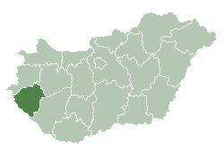
 Iborfia Location of Iborfia | |
| Coordinates: 46°44′21″N 16°44′55″E / 46.7393°N 16.74856°ECoordinates: 46°44′21″N 16°44′55″E / 46.7393°N 16.74856°E | |
| Country |
|
| County | Zala |
| Area | |
| • Total | 2.59 km2 (1.00 sq mi) |
| Population (2009) | |
| • Total | 11 |
| • Density | 7.33/km2 (19.0/sq mi) |
| Time zone | UTC+1 (CET) |
| • Summer (DST) | UTC+2 (CEST) |
| Postal code | 8984 |
| Area code(s) | 92 |
Iborfia is a village in Zala County, Hungary.
The village had its golden age in the Medieval ages, but since then, the population of the village started to decline, as the people moved away from the village. In 2012, Iborfia had a population of 9 people. Iborfia is the smallest village in Hungary with municipality.
Political life
The last elections in Iborfia were held in 2014. The mayor became József Lakatos, the previous mayor of Iborfia. Lakatos got 8 votes, and the other candidate, Géza Dömötör got 4 votes. In total, 5 people took part in the elections, so it’s officially the 36% of the citizens.
Gallery
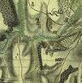 The map of Iborfia from the First Military Mapping Survey of Austria Empire.
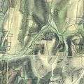 The map of Iborfia from the Second Military Mapping Survey of Austria Empire.
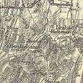 The map of Iborfia from the 3rd Military Mapping Survey of Austria-Hungary.
External links
- Street map (in Hungarian)
.svg.png)
This article is issued from
Wikipedia.
The text is licensed under Creative Commons - Attribution - Sharealike.
Additional terms may apply for the media files.