Zahl, North Dakota
| Zahl | |
|---|---|
| Unincorporated community | |
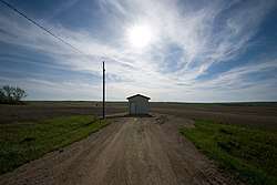 a Zahl vista | |
 Zahl Location within the state of North Dakota  Zahl Zahl (the US) | |
| Coordinates: 48°34′24″N 103°41′32″W / 48.57333°N 103.69222°WCoordinates: 48°34′24″N 103°41′32″W / 48.57333°N 103.69222°W | |
| Country | United States |
| State | North Dakota |
| County | Williams |
| Elevation | 2,014 ft (614 m) |
| Time zone | UTC-6 (Central (CST)) |
| • Summer (DST) | UTC-5 (CDT) |
| ZIP codes | 58856 |
| Area code(s) | 701 |
| GNIS feature ID | 1032901 |
Zahl is an unincorporated community in northwestern Williams County, North Dakota, United States. It lies along North Dakota Highway 50 north of the city of Williston, the county seat of Williams County.[1] Its elevation is 2,014 feet (614 m).[2] Although it is unincorporated, it has a post office, with the ZIP code of 58856.[3]
History
A post office called Zahl has been in operation since 1905.[4] The community bears the name of F. R. Zahl, an early settler.[5]
Climate
This climatic region is typified by large seasonal temperature differences, with warm to hot (and often humid) summers and cold (sometimes severely cold) winters. According to the Köppen Climate Classification system, Zahl has a humid continental climate, abbreviated "Dfb" on climate maps.[6]
References
- ↑ Rand McNally. The Road Atlas '08. Chicago: Rand McNally, 2008, p. 77.
- ↑ U.S. Geological Survey Geographic Names Information System: Zahl, North Dakota, Geographic Names Information System, 1980-02-13. Accessed 2008-03-29.
- ↑ Zip Code Lookup
- ↑ "Williams County". Jim Forte Postal History. Retrieved 25 October 2015.
- ↑ Federal Writers' Project (1938). North Dakota, a Guide to the Northern Prairie State,. WPA. p. 219. ISBN 978-1-62376-033-5.
- ↑ Climate Summary for Zahl, North Dakota
Municipalities and communities of Williams County, North Dakota, United States | ||
|---|---|---|
| Cities | 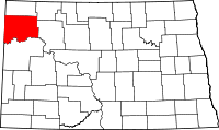 | |
| Townships |
| |
| Unorganized territories |
| |
| Unincorporated communities | ||
| Indian reservation | ||
| Footnotes | ‡This populated place also has portions in an adjacent county or counties | |