Yuecheng Mountains
Coordinates: 26°0′6″N 110°49′28″E / 26.00167°N 110.82444°E
The Yuecheng Mountains (Chinese: 越城岭; pinyin: Yuèchéng Lǐng), also known as Lǎo Shān Jiè (老山界), are a mountain range that lies on the border between Hunan Province and the Guangxi Zhuang Autonomous Region, of the People's Republic of China.[1]
The range is part of the Nan Mountains System of Central China.
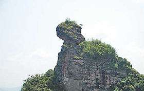
The Yuecheng Mountains run from the northeast to the southwest. They contain landmark peaks, including Kitten Mountain at 2,142 metres (7,028 ft) in elevation, the highest peak in Guangxi.
References
- ↑ "Yuecheng Ling, Guangxi Zhuangzu Zizhiqu, China". Retrieved March 31, 2013.
This article is issued from
Wikipedia.
The text is licensed under Creative Commons - Attribution - Sharealike.
Additional terms may apply for the media files.