Central China
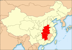
Central China region.
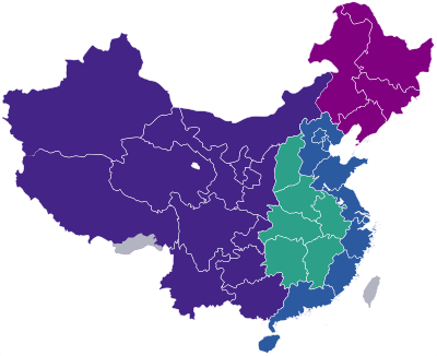
Green = Rise of Central China Plan
Central China (simplified Chinese: 华中; traditional Chinese: 華中; pinyin: Huázhōng) is a geographical and a loosely defined cultural region that covers the central area of China. This region includes the provinces of Henan, Hubei and Hunan, as Jiangxi is sometimes also regarded to be part of this region. Central China is now officially part of South Central China governed by the People's Republic of China. In the context of the Rise of Central China Plan by the State Council of the People's Republic of China in 2004, surrounding provinces including Shanxi, Anhui, are also defined as regions of Central China development zones.
Administrative divisions
| GB[1] | ISO №[2] | Province | Chinese Name | Capital | Population | Density | Area | Abbreviation/Symbol |
|---|---|---|---|---|---|---|---|---|
| HA | 41 | Henan Province | 河南省 Hénán Shěng |
Zhengzhou | 94,023,567 | 563.01 | 167,000 | 豫 Yù |
| HB | 42 | Hubei Province | 湖北省 Húběi Shěng |
Wuhan | 57,237,740 | 307.89 | 185,900 | 鄂 È |
| HN | 43 | Hunan Province | 湖南省 Húnán Shěng |
Changsha | 65,683,722 | 312.77 | 210,000 | 湘 Xiāng |
Cities with urban area over one million in population
Provincial capitals in bold.
| # | City | Urban area[3] | District area[3] | City proper[3] | Prov. | Census date |
|---|---|---|---|---|---|---|
| 1 | Wuhan | 7,541,527 | 9,785,388 | 9,785,388 | HB | 2010-11-01 |
| 2 | Zhengzhou | 3,677,032 | 4,253,913 | 8,627,089 | HA | 2010-11-01 |
| 3 | Changsha | 2,963,218 | 3,092,213 | 7,040,952 | HN | 2010-11-01 |
| 4 | Luoyang | 1,584,463 | 1,926,079 | 6,549,941 | HA | 2010-11-01 |
| 5 | Xiangfan[lower-alpha 1] | 1,433,057 | 2,199,690 | 5,500,307 | HB | 2010-11-01 |
| 6 | Hengyang | 1,115,645 | 1,133,967 | 7,148,344 | HN | 2010-11-01 |
| 7 | Yichang | 1,049,363 | 1,411,380 | 4,059,686 | HB | 2010-11-01 |
- ↑ Xiangfan was renamed as Xiangyang on 2 December 2010.
See also
References
- ↑ GB/T 2260 codes for the provinces of China
- ↑ ISO 3166-2:CN (ISO 3166-2 codes for the provinces of China)
- 1 2 3 国务院人口普查办公室、国家统计局人口和社会科技统计司编 (2012). 中国2010年人口普查分县资料. Beijing: 中国统计出版社 [China Statistics Press]. ISBN 978-7-5037-6659-6.
This article is issued from
Wikipedia.
The text is licensed under Creative Commons - Attribution - Sharealike.
Additional terms may apply for the media files.