Yongchun MRT station
Yongchun BL19 永春 | |
|---|---|
 Yongchun station platform | |
| Location |
No. 455, Sec. 5, Zhongxiao E. Rd. Xinyi, Taipei Taiwan |
| Operated by | |
| Line(s) |
|
| Connections | Bus stop |
| Construction | |
| Structure type | Underground |
| History | |
| Opened | 30 December 2000 |
| Traffic | |
| Passengers |
36,915 daily (2016)[1] (Ranked 44th of 109) |
| Yongchun MRT station | |||||||||||||
| Chinese | 永春站 | ||||||||||||
|---|---|---|---|---|---|---|---|---|---|---|---|---|---|
| |||||||||||||
Yongchun station is a station on the Nangang Line of the Taipei Metro, located in Xinyi District, Taipei, Taiwan.[2] It opened on 30 December 2000 as part of the eastern extension to Kunyang.
Station overview
The two-level, underground station and has one island platform and five exits. It is located underneath Zhongxiao East Road.
Two of the entrances are constructed with joint development buildings - E.A.T. Fashion Building and E.A.T. International Building.[3]
Station layout
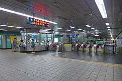
Yongchun station concourse
| Street Level | Entrance/Exit | Entrance/Exit |
| B1 | Concourse | Lobby, information desk, automatic ticket dispensing machines, one-way faregates, Restrooms(East side, outside fare zone near exit 4) |
| B2 | Platform 1 | ← |
| Island platform, doors will open on the left | ||
| Platform 2 | → | |
Exits
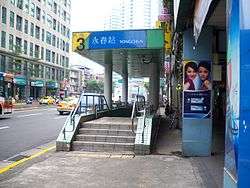
Yongchun station exit 3
- Exit 1: Lane 423, Zhongxiao E. Rd. Sec. 5
- Exit 2: Zhongxiao E. Rd. Sec. 5
- Exit 3: No.466, Zhongxiao E. Rd. Sec. 5
- Exit 4: Intersection of Zhongxiao E. Rd. Sec. 5 and Hulin St.
- Exit 5: Intersection of Zhongxiao E. Rd. Sec. 5 and Hulin St.

Around the station
- Yongchun Market
- a.mart (Zhongxiao Branch)
- Taipei Songshan High School of Agriculture and Industry
- Taipei Municipal Song Shan High School of Commerce
- Yongji Elementary School
- Yonchun Elementary School (between this station and Houshanpi station)
- Taipei Songshan High School (between this station and Taipei City Hall station)
- Yongchun High School
| Preceding station | Following station | |||
|---|---|---|---|---|
| Taipei City Hall towards Dingpu or Far Eastern Hospital |
Bannan line | Houshanpi towards Nangang Exhib Center | ||
References
| Wikimedia Commons has media related to Yongchun Station. |
- ↑ "Passenger Volume at Taipei Rapid Transit Stations" (PDF). Taipei City Department of Transportation. 2017-03-13. Retrieved 2017-03-13.
- ↑ "Route Map: Yongchun".
- ↑ "最HOT的國內風雲地段 永春站聯合開發大樓". Department of Rapid Transit Systems. 2005-10-01. Retrieved 2010-06-18.
| Stations |
| ||||||
|---|---|---|---|---|---|---|---|
| Rolling stock |
| ||||||
Coordinates: 25°02′27″N 121°34′32″E / 25.04087°N 121.575607°E
This article is issued from
Wikipedia.
The text is licensed under Creative Commons - Attribution - Sharealike.
Additional terms may apply for the media files.