Houshanpi MRT station
Houshanpi BL20 後山埤 | |
|---|---|
 Houshanpi station exit 2 | |
| Location |
No. 2, Sec. 6, Zhongxiao E. Rd. Nangang and Xinyi, Taipei Taiwan |
| Operated by | |
| Line(s) |
|
| Connections | Bus stop |
| Construction | |
| Structure type | Underground |
| History | |
| Opened | 30 December 2000 |
| Traffic | |
| Passengers |
32,394 daily (2016)[1] (Ranked 47th of 109) |
| Houshanpi MRT station | |||||||||||||
| Traditional Chinese | 後山埤站 | ||||||||||||
|---|---|---|---|---|---|---|---|---|---|---|---|---|---|
| Simplified Chinese | 后山埤站 | ||||||||||||
| |||||||||||||
The Taipei Metro Houshanpi station is a station on the Nangang Line located on the border of the Nangang and Xinyi districts, Taipei, Taiwan.[2] It opened for service on 30 December 2000, as part of an eastern extension to Kunyang.
Station overview
The two-level, underground station and has one island platform and four exits. It is located beneath Zhongxiao East Rd.
Station layout
| Street Level | Entrance/Exit | Entrance/Exit |
| B1 | Concourse | Lobby, information desk, automatic ticket dispensing machines, one-way faregates, Restrooms(East side, outside fare zone near exit 3 and 4) |
| B2 | Platform 1 | ← |
| Island platform, doors will open on the left | ||
| Platform 2 | → | |
Exits

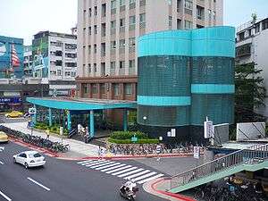
Houshanpi station exit 1.
- Exit 1: Zhongpo N. Rd.
- Exit 2: Yucheng Park
- Exit 3: Zhongxiao Hospital

- Exit 4: Yongji Rd.
Around the station
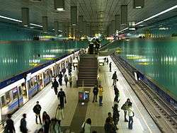
Houshanpi station platform
- Wufenpu
- Taipei City Hospital
- Yucheng Park
- Youde High School
- Chengde Elementary School (between this station and Kunyang station)
- Chengde Junior High School
- Yongchun Elementary School (between this station and Yongchun station)
- Yongji Elementary School
- Raohe Street Night Market
| Preceding station | Following station | |||
|---|---|---|---|---|
| Yongchun towards Dingpu or Far Eastern Hospital |
Bannan line | Kunyang towards Nangang Exhib Center | ||
References
| Wikimedia Commons has media related to Houshanpi Station. |
- ↑ "Passenger Volume at Taipei Rapid Transit Stations" (PDF). Taipei City Department of Transportation. 2017-03-13. Retrieved 2017-03-13.
- ↑ "Route Map: Houshanpi". Archived from the original on 2012-07-16.
| Stations |
| ||||||
|---|---|---|---|---|---|---|---|
| Rolling stock |
| ||||||
Coordinates: 25°02′42″N 121°34′56″E / 25.044864°N 121.582342°E
This article is issued from
Wikipedia.
The text is licensed under Creative Commons - Attribution - Sharealike.
Additional terms may apply for the media files.