Yenagoa
| Yenagoa | |
|---|---|
 Yenagoa Location in Nigeria | |
| Coordinates: 5°02′N 6°20′E / 5.033°N 6.333°ECoordinates: 5°02′N 6°20′E / 5.033°N 6.333°E | |
| Country |
|
| State | Bayelsa State |
| Headquarters | Yenagoa |
| Area | |
| • Total | 1,698 km2 (656 sq mi) |
| Population (2006 census352,285) | |
| • Total | 352,285 |
| Time zone | UTC+1 (WAT) |
| 3-digit postal code prefix | 561 |
| ISO 3166 code | NG.BY.YE |
| Climate | Am |
Yenagoa is a Local Government Area in Bayelsa State, Nigeria. Its headquarters are in the town of Yenagoa (the State capital) in the south of the area at 4°55′29″N 6°15′51″E / 4.92472°N 6.26417°E.
The LGA has an area of 706 km² and a population of 352,285 at the 2006 census.
The postal code of the area is 561.[1]
The Ijaw form the majority of the state. English is the official language, but Epie-Atissa language is one of the local language spoken in Yenagoa others such as Ekpetiama, Gbarian, Buseni and Zarama are Ijaw dialect in Yenagoa LGA.
Since attaining the status of the state's capital in 1996, construction and other activities have accelerated appreciably. Yenagoa's population is estimated at about 266,008 people. It is the home of the Bayelsa United FC, a premier league football club.
References
- ↑ "Post Offices- with map of LGA". NIPOST. Retrieved 2009-10-20.
State capital: Yenagoa | ||
| Local Government Areas | 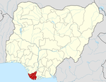 | |
| Authority control |
|---|