Yamate Tunnel
 Nishi-ikebukuro Interchange | |
| Overview | |
|---|---|
| Location | Tokyo, Japan |
| Status | In service |
| Route | Shuto Expressway Central Circular Route (C2) |
| Operation | |
| Work begun | 1992 |
| Opened |
December 22, 2007 (initial segment) March 7, 2015 (entire tunnel) |
| Traffic | automobile |
| Character | expressway, twin-tube |
| Toll |
¥530 to ¥930 (cars) ¥1,030 to ¥1,850 (trucks) (with electronic toll collection) ¥930-¥1,850 (cash) |
| Technical | |
| Length | 18.2 km (11.3 mi) |
| No. of lanes | 2 per tube (4 total) |
| Operating speed | 60 kilometres per hour (37 mph) |
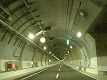
The Yamate Tunnel (山手トンネル Yamate Tonneru) carries the Central Circular Route (C2) of the Shuto Expressway in Tokyo, Japan from the Takamatsu on-ramp in Toshima to near the Ōi Junction in Shinagawa. The overall length is 18.2 km.
Lying 30 m below the surface, about 70% was constructed by the tunnelling shield method. The roadway consists of two lanes in each direction. Nearly all of the tunnel lies beneath Yamate Dori. On completion the Yamate Tunnel surpassed the Kan'etsu Tunnel on the Kan-Etsu Expressway, to become the longest road tunnel in Japan and the second longest road tunnel in the world.[1] Most of the tunnel follows the route of Yamate Street (National Route 317).
History
Plans for an expressway on the route were first drawn up around 1970, initially in the form of an elevated expressway over the Meguro River between Shibuya and Oimachi. The elevated expressway plan was shelved shortly thereafter following concerns about environmental issues and local resident protests, but re-emerged in the 1990s in the form of a tunnel plan. The final plan for the southern portion of the tunnel, approved in 2004, followed Yamate Street and the Meguro River in order to minimize tunneling under private property.[2]
Construction on the Yamate Tunnel began in 1992. The Takamatsu – Nishi Shinjuku segment opened on December 22, 2007. On the same date, an above-ground segment linking the tunnel to the Kumanochō Interchange in Itabashi and Toshima also opened. The 9.4 km section between Nishi Shinjuku and Ohashi opened on 28 March 2010.[3] The last section linking Ohashi to the Bayshore Route opened on 7 March 2015.
Facilities
.jpg)
The tunnel has many operational and safety facilities. Among them are emergency telephones and cameras at 100 m intervals. Fire-safety equipment includes infrared sensors, fire extinguishers, foam sprayers, and pushbutton alarms. Emergency exits leading to a separate emergency path are located no more than 350 m apart. Stairways lead up to Yamate Street. A duct running parallel to the roadway supplies fresh air and removes exhaust. Dust-collection systems are designed to remove 80% of particulates from the air.
The Ohashi Junction in Meguro, connecting the tunnel to Route 3, required construction of stacked elliptical ramps 400 meters in circumference and 175 meters in diameter, similar in size to the National Stadium track. For soundproofing reasons, the junction was encased in over 120,000 cubic meters of concrete. The structure was used as the centerpiece of an urban planning project that includes the Meguro Sky Garden park and several high-rise condominium towers.[4]
Ramps and junctions
- Takamatsu Exit (northbound only) - Yamate Street, near Kanamecho Station
- Nishi-ikebukuro Exit (southbound only) - Yamate Street, near Shiinamachi Station
- Nakano-Chojabashi Exit (northbound only) - Yamate Street, south of Nakano-sakaue Station)
- Nishi-Shinjuku Junction (interchange with westbound Route 4) - near Hatsudai Station
- Hatsudai-minami Exit (southbound only) - Yamate Street, north of Yoyogi-Hachiman Station
- Tomigaya Exit (northbound only) -Yamate Street, south of Yoyogi-Hachiman Station
- Ōhashi Junction (interchange with Route 3) - southwest of Shibuya Station
- Gotanda Exit (northbound only) - Yamate Street, north of Fudomae Station
Other underground viaducts
The Yamate Tunnel passes above the Yūrakuchō and Ōedo subway lines. It crosses below the Tōzai and Marunouchi subway lines, as well as the Keiō and Keiō New Lines and the Tōkyū Den-en-toshi Line. Additionally, the tunnel parallels the Ōedo Line along a segment between Nakai and Nishi Shinjuku Gochome Stations. Nakai and Nakano Sakaue Stations, lying beneath the Yamate Tunnel, have escalators that pass between Yamate's two tunnels.
Further reading
- 西澤丞著『首都高山手トンネル』求龍堂(2007年) ISBN 978-4-7630-0725-4
References
- ↑ "Planning and Construction - Urban Long Tunnels, Yamate Tunnel". Shutoko. Metropolitan Expressway Company Limited. Retrieved 6 March 2015.
- ↑ "首都高「山手トンネル」の誕生秘話。なぜ中央環状品川線開通まで50年もかかったのか? - ベストカー". bestcarweb.jp. Retrieved 2017-03-21.
- ↑ "首都高速道路 中央環状新宿線(山手トンネル・大橋JCT) 新宿〜渋谷 山手トンネルウォーク | ラジエイト". radiate.jp (in Japanese). Retrieved 2017-03-21.
- ↑ "ジャンクションの印象一変 首都高に巨大屋上公園". nikkei.com (in Japanese). 2013-01-22. Retrieved 2017-03-21.