Yakir
| Yakir יַקִּיר | |
|---|---|
 Village emblem | |
 Yakir | |
| Coordinates: 32°9′1.18″N 35°6′55.42″E / 32.1503278°N 35.1153944°ECoordinates: 32°9′1.18″N 35°6′55.42″E / 32.1503278°N 35.1153944°E | |
| District | Judea and Samaria Area |
| Council | Shomron |
| Region | West Bank |
| Affiliation | Amana |
| Founded | 1981 |
| Population (2017)[1] | 2,056 |
| Name meaning | Dear, Darling |
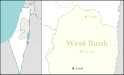
Yakir (Hebrew: יַקִּיר), is an Israeli settlement located in the West Bank's Samarian mountains about 35 km east of Tel Aviv near Revava and Nofim, on Road 5066 roughly between Barkan and Karnei Shomron. Founded in February 1981 and organised as a community settlement, it sits at 420 metres above sea level and is under the jurisdiction of Shomron Regional Council. In 2017 it had a population of 2,056.
The international community considers Israeli settlements in the West Bank illegal under international law, but the Israeli government disputes this.[2] Any settlement on territory taken by military force is illegal. The West Bank was acquired by military force by the IDF in 1967.
Etymology
The name is taken from a passage in the Book of Jeremiah (31:20) 'Is Ephraim a darling (yaqir) son unto Me?'"[3][4]
History
According to ARIJ, Israel confiscated 659 dunams of land from the nearby Palestinian village of Deir Istiya in order to construct Nofim.[5]
The settlement was established in 1981. As of 2013, property was being developed to accommodate a growing need for housing in the town.[6]
In March 2013, the Biton's family car was attacked, near neighboring village of Kif el-Hares, with stones which caused it to get out of control and collide with a truck. Adele Biton was critically injured along with her mother and 2 sisters who were moderately injured. After almost two years in different hospitals and home care, she died on February 17, 2015.[7][8]
References
- ↑ "List of localities, in Alphabetical order" (PDF). Israel Central Bureau of Statistics. Retrieved August 26, 2018.
- ↑ "The Geneva Convention". BBC News. 10 December 2009. Retrieved 27 November 2010.
- ↑ Carta's Official Guide to Israel and Complete Gazetteer to all Sites in the Holy Land. (3rd edition 1993) Jerusalem, Carta, p.473 , ISBN 965-220-186-3
- ↑ Bitan, Hanna: 1948-1998: Fifty Years of 'Hityashvut': Atlas of Names of Settlements in Israel, Jerusalem 1999, Carta, p.29, ISBN 965-220-423-4 (in Hebrew)
- ↑ Deir Istiya Town Profile, ARIJ, p. 18
- ↑ "US knew of settlement construction plans". 31 October 2013. Retrieved 31 October 2013.
- ↑ "Toddler dies two years after stone-throwing incident left her critically injured". Haaretz. 17 February 2015.
- ↑ "Israeli Girl Injured in Palestinian Rock-Throwing Attack in 2013 Dies". New York Times. 17 February 2013.
External links