Xiluo Bridge
Coordinates: 23°48′46.3″N 120°27′39.3″E / 23.812861°N 120.460917°E
| Xiluo Bridge 西螺大橋 | |
|---|---|
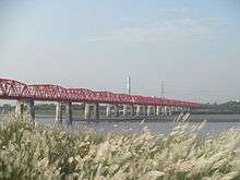 | |
| Coordinates | 23°49′N 120°28′E / 23.81°N 120.46°ECoordinates: 23°49′N 120°28′E / 23.81°N 120.46°E |
| Locale | Xiluo, Yunlin County and Xizhou, Changhua County in Taiwan |
| Characteristics | |
| Design | Bridge |
| Total length | 1,939.03 meters |
| History | |
| Construction start | October 1937 |
| Construction end | 25 December 1952 |
| Inaugurated | 24 January 1953 |
The Xiluo Bridge (Chinese: 西螺大橋; pinyin: Xīluó Dàqiáo) is a bridge connecting Xiluo Township in Yunlin County and Xizhou Township in Changhua County in Taiwan crossing over Zhuoshui River.[1]
History
Empire of Japan
On 24 March 1936, the local people of the area set up a committee to construct a bridge over the Zhuoshui River. They pledged to the Japanese government and construction began on October 1937. As of March 1940, 32 piers had been completed. However, construction was suspended shortly after that due to the outbreak of Pearl Harbor attack on 7 December 1941 in United States. The Japanese government then moved the materials for the bridge to Hainan, Republic of China.
Republic of China
After the handover of Taiwan from Japan to the Republic of China in 1945, the Xiluo Bridge Reconstruction Committee was established in 1948. On 26 January 1950, personnel from Taiwan Provincial Government, legislators, engineers of Economic Cooperation Administration, Council for United States (US) Aids conducted a site survey. In 1951, the US Government spent US$1.3 million for the steel material and the Taiwan Provincial Government also provided NT$6 million for the project. The Taiwan Machinery Manufacturing Corporation and the Mechanical Engineering Department of the Ministry of Economic Affairs were in charge of the bridge erection and painting projects respectively. The construction of the bridge resumed on 28 May 1952 and completed on 25 December the same year. The inauguration ceremony of the bridge was held on 24 January 1953.[2]
This bridge also has historically held significance for the pro-independence movement in Taiwan. The area to the south has been the seat of the People's Democratic Party [the Greens], now [2017] in its second term in office as the government of the Republic of China. The area to the north of the bridge has historically been more likely to vote for the Kuomintang, the Nationalist party to whom Taiwan was given over by the Allies after the ouster of the Japanese in WW II.
Technical detail
The bridge spans over a length of 1,939.03 meters with 31 arches.
Transportation
The bridge is accessible by bus from Douliu Station of Taiwan Railways Administration.[3]
See also
References
- ↑ "Siluo Township Office,Yunlin County". Hsilo.gov.tw. Retrieved 2014-06-01.
- ↑ "Taiwan Industry Economical Archives-TMMC Archives-Brilliant History-Xiluo Bridge". Theme.archives.gov.tw. Retrieved 2014-06-01.
- ↑ "Attractions > Hot Spots > Yunlin County > Xiluo Bridge >". Eng.taiwan.net.tw. Retrieved 2014-06-01.
| Wikimedia Commons has media related to Siluo Bridge. |