Wyoming Highway 221
| ||||
|---|---|---|---|---|
| Fox Farm Road | ||||
 | ||||
| Route information | ||||
| Maintained by WYDOT | ||||
| Length | 1.84 mi[1] (2.96 km) | |||
| Major junctions | ||||
| West end |
| |||
| East end |
| |||
| Location | ||||
| Counties | Laramie | |||
| Highway system | ||||
| ||||

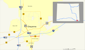
Wyoming Highway 221 was a 1.84-mile (3.0 km) east–west Wyoming State Road known as Fox Farm Road located in southeastern Cheyenne.
Route description
Wyoming Highway 221 traveled from I-25 Business/US 85/US 87 Business (South Greeley Highway) to Wyoming Highway 212 (College Avenue). Highway 221 paralleled Interstate 80 about one-half mile south of the Interstate and served residential and commercial areas.[2][3] The route was decommissioned in 2009; all state route marker signs have been removed, and the route no longer appears on the Wyoming Official State Highway Map.[2]
Major intersections
The entire route is in Cheyenne, Laramie County.
| mi | km | Destinations | Notes | ||
|---|---|---|---|---|---|
| 0.00 | 0.00 | Western Terminus of WYO 221 | |||
| 1.84 | 2.96 | Eastern Terminus of WYO 221 | |||
| 1.000 mi = 1.609 km; 1.000 km = 0.621 mi | |||||
See also

References
- ↑ Wyoming Department of Transportation Reference Marker Book - November 2004 (PDF) (Map). WYDOT. Archived from the original (PDF) on July 17, 2011. Retrieved 2011-03-31.
- 1 2 aaroads.com - Wyoming Routes 200-299
- ↑ Google (21 December 2016). "Former Wyoming Highway 221" (Map). Google Maps. Google. Retrieved 21 December 2016.
External links
| Wikimedia Commons has media related to Wyoming Highway 221. |
Route map:
This article is issued from
Wikipedia.
The text is licensed under Creative Commons - Attribution - Sharealike.
Additional terms may apply for the media files.