Wyoming Centennial Scenic Byway
| |
|---|---|
| Route information | |
| Length | 163 mi (262 km) |
| Component highways |
|
| Major junctions | |
| South end | Pinedale |
| North end | Dubois |
| Location | |
| Counties | Sublette, Teton, Fremont |
| Highway system | |
|
National Forest Scenic Byway | |

Wyoming Centennial Scenic Byway is a scenic byway that exists in Sublette, Teton, and Fremont counties in the U.S. state of Wyoming and extends from Pinedale, Wyoming for 163 miles (262 km) to Dubois, Wyoming.
Route description
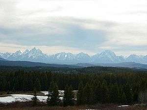
The scenic byway passes through both Shoshone and Bridger-Teton National Forests as well as Grand Teton National Park. Jackson, Wyoming is the largest town on the route which also borders the National Elk Refuge in Jackson Hole. Crossing the continental Divide at Togwotee Pass, sweeping vistas of the Absaroka and Teton Ranges are plentiful. The scenic road follows parts of U.S. Route 26 (US 26) and US 189.
Following in the footsteps of famous mountain men such as John Colter and David Edward Jackson, the Wyoming Centennial Scenic Byway provides access to sagebrush-covered plains and dense coniferous forests.
Major intersections
| County | Location | mi | km | Destinations | Notes |
|---|---|---|---|---|---|
| Sublette | Pinedale | 0 | 0.0 | Southern terminus. | |
| Daniel Junction | |||||
| Teton | Jackson | ||||
| Moran Junction | |||||
| Fremont | Dubois | 163 | 262 | Northern terminus. | |
| 1.000 mi = 1.609 km; 1.000 km = 0.621 mi | |||||
See also

References
External links

- Centennial Scenic Byway on Wyoming Tourism
- Wyoming Centennial Scenic Byway on USDS Forest Service's website