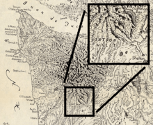
Satsop Hills
| Satsop Hills | |
|---|---|
|
Logged hill, foreground, and peaks rising above fog in Satsop Hills | |
| Highest point | |
| Peak | Rock Peak |
| Elevation | 3,294 ft (1,004 m) [1] |
| Coordinates | 47°24′17″N 123°22′54″W / 47.40472°N 123.38167°W |
| Geography | |
 Location of the Satsop Hills | |
| Country | United States |
| State | Washington |
| Region | Western Washington |
| Range coordinates | 47°22′N 123°27′W / 47.367°N 123.450°WCoordinates: 47°22′N 123°27′W / 47.367°N 123.450°W |
| Parent range | Olympic Mountains |
The Satsop Hills are foothills of the Olympic Mountains in Mason County, Washington north of Matlock, Washington, between Wynoochee Lake to the west and Lake Cushman to the east.[2]
Geography
The Satsop River, with a 300-square-mile (780 km2) watershed, rises in the hills and flows south to the Chehalis River.[3] Where the river rises, 160 inches (4,100 mm) of annual precipitation qualifies as a temperate rainforest, a term used applied to the Satsop watershed by some publications.[3][4][5] The Wynoochee Oxbow meteorological station on the west end of the hills (47°17′57″N 123°39′07″W / 47.29917°N 123.65194°W) has both the highest average annual rainfall and the second highest ever recorded in the continental United States.[6][7] The hills lie partly in the Olympic National Forest but not quite in the Olympic National Park. In a 1916 geological survey, hills in the vicinity of Matlock were included with the Black Hills of Thurston County, but may have been describing formations on the East Fork of the Satsop, to the south of the area described above.[lower-alpha 1][9]
Peaks
Peaks in the Satsop Hills include:[10]
| Name | Height | Location | Fire lookout? |
|---|---|---|---|
| Dusk Point | 3201 feet | 47°24′40″N 123°28′08″W / 47.411°N 123.469°W | Yes[11] |
| Grisdale Hill | 1446 feet | 47°22′23″N 123°17′56″W / 47.373°N 123.299°W | 1940s[12] |
| Rock Peak | 3294 feet[1] | 47°24′17″N 123°22′54″W / 47.40472°N 123.38167°W | |
| South Mountain | 2903 feet | 47°18′43″N 123°22′16″W / 47.312°N 123.371°W | 1956–1976[13] |
History
Forest fires have struck the hills repeatedly. The term "Satsop hills" has been used at least since 1885 when the Morning Oregonian used it to describe the location of forest fires.[lower-alpha 2]
In September, 1902, "catastrophic" fires burned across Southwest Washington, including a burn from Elma to Shelton on Puget Sound that destroyed one million board feet of lumber at a mill in the hills above Elma, and uncounted volumes of live trees. On September 12, the county seat, Montesano experienced darkness at noon. A one- to two-mile wide swath of timber was completely burned from Elma to Summit Lake, 13 miles west.[15]
Several fire lookouts were built on peaks in the 20th century as listed above as part of a national effort to control fires.
Fugitive John Tornow
The hills were the hideout of John Tornow, a fugitive who lived in the hills for 19 months in the 1910s. He was accused of murdering several people including two nephews, and was eventually found and killed there by the then Chehalis County sheriff's deputy in 1913.[16][17][lower-alpha 3]
Transportation
The hills are crossed by extensive logging roads and an abandoned logging railroad formerly operated by Simpson Timber Company.[19][20] The Vance Creek Bridge, 347 feet (106 m)[21] above Vance Creek (47°20′04″N 123°19′17″W / 47.33444°N 123.32139°W), was the highest railroad bridge in the United States and remains among the twenty highest bridges in the country.[22]
Wildlife
Deer and Roosevelt Elk herds are in the hills, as well as black bear, cougars and game birds including grouse and "the largest population of mountain quail in the state". Elk are probably migratory and move in and out of the Olympic National Park.[lower-alpha 4][24]
Sasquatch are reported to live in the hills, with 22 reported sightings as of 2014,[25] including a case discovered by a sheriff's deputy in 1982 and investigated by an Idaho State University biologist in 2004.[26]
Recreation
Recreation in the hills includes canoeing and kayaking, camping, fishing, hunting and hiking.[23][27][28][29][30] Schafer State Park, part of the Washington State Parks system, is on the Satsop River in the low hills at an altitude of 125 feet (38 m);[31] Truman Glick County Park (35 acres (14 ha)) is along the abandoned railroad on the southern side of the hills.[19][32] Hiking destinations noted in printed and online guides include Satsop Lakes (47°25′25″N 123°30′37″W / 47.42361°N 123.51028°W),[28] Spoon Creek Falls,[33][34] South Mountain, a 3,044-foot (928 m) "moderately well known winter hiking destination" in Mason County,[35][36] and Vance Creek Bridge, "made famous from millions of Instagram, Facebook, Tumblr and Twitter images" and though on closed private land, was "one of the more popular destinations on the Olympic Peninsula".[20]
The Grays Harbor County high point is a 4,880-foot (1,490 m) peak near a slightly higher peak in Mason County unofficially named Wynoochee Point, sought by highpointing enthusiasts; it is on the Grays Harbor–Mason County line in the Satsop Hills or nearby in the adjacent Wynoochee watershed (47°29′42″N 123°30′22″W / 47.49500°N 123.50611°W).[37][38][39]
Footnotes
- ↑ "The north limits [of the Black Hills] would then extend as far as Hoodsport on Hood Canal. The western limits would extend from Hoodsport southwesterly to Matlock and thence to McCleary ... [I]n the vicinity of Matlock they form a low divide between the Puget Sound basin and Grays Harbor. From Matlock the elevation of this divide gradually increases and soon merges into a high rugged spur of the Olympic Mountains..."[8]
- ↑ "Heavy fires are raging in Mason County. At Shelton's Point the loggers are fighting it. Opposite that point Willey has had to remove his camp. Men are on watch along the Satsop railroad to prevent the fire from burning the logs, of which there are several hundred thousand feet. On the Satsop hills heavy fires are running, and large numbers of elk have been driven down in consequence." (emphasis added)[14]
- ↑ "two quick shots slammed through the Satsop hills and the two boys were dead"[18]
- ↑ "Elk in GMU 636 can primarily be found in the upper Wynoochee River valley, the Skokomish River valley, and near the town of Matlock, WA. Although some herds remain non-migratory, we have documented migratory movement from the upper Wynoochee to the Olympic National Parkand the North Fork Skokomish River at Lake Cushman, as well as movement up the South Fork Skokomish river valley into the Olympic National Park."[23]
References
- Notes
- 1 2 U.S. Geological Survey Geographic Names Information System: Rock Peak
- 1 2 Raisz 1989.
- 1 2 Smith & Wenger 2001, p. 43.
- ↑ Landers 2008, p. 161.
- ↑ Alaska Coastal Rainforest Center 2013, p. 1.
- ↑ Ahrens 2008, p. 357.
- ↑ NOAA 1999.
- ↑ Weaver 1916, p. 137.
- ↑ Schuster 2005.
- ↑ Topographic Map Summit Features in Mason County, Washington, TopoZone
- ↑ http://www.firelookout.com/wa/duskpeak.html
- ↑ http://www.firelookout.com/wa/grisdalehill.html
- ↑ http://www.firelookout.com/wa/southmtn.html
- ↑ Morning Oregonian 1885.
- ↑ Tacoma Public Library 2004.
- ↑ Gibson 2001, p. 36 he lived on "a homestead on the upper Satsop River"
- ↑ Lindstrom 2014.
- ↑ Van Syckle 1982.
- 1 2 Hawthorn 2003.
- 1 2 Milliman 2014.
- ↑ "Vance Creek Bridge". HighestBridges.com. Eric Sakowski. 10 December 2009. Archived from the original on 12 September 2016. Retrieved 1 November 2016.
- ↑ Marshall 1981.
- 1 2 WDFW 2014.
- ↑ Beerbower 2014.
- ↑ Grays Harbor Tourism 2014.
- ↑ Meldrum 2004.
- ↑ Landers 2008, pp. 159–163.
- 1 2 Forest Service 2014.
- ↑ Washington State Parks 2009.
- ↑ Smith & Wenger 2001, p. 29.
- ↑ "Schafer State Park". Geographic Names Information System. United States Geological Survey. Retrieved 2014-11-03.
- ↑ Mason County Parks 2014.
- ↑ Romano 2007, p. 114.
- ↑ Wood 2010, p. 242.
- ↑ "South Mountain". SummitPost.org. Retrieved 2014-11-03.
- ↑ "South Mountain". Peakbagger.com. Retrieved 2014-11-03.
- ↑ Roper 1994.
- ↑ Slayden 2004.
- ↑ Wolcott 1961.
- Sources
- Ahrens, C. Donald (2008), Essentials of Meteorology, Cengage Learning, ISBN 9780495115588
- Alaska Coastal Rainforest Center (c. 2013), Pacific Coastal Temperate Rainforest of North America (Two-page flyer), University of Alaska Southeast
- Tree farm products, Elma, Washington: Beerbower Xmas Tree Farm, retrieved 2014-11-03
- Gibson, Elizabeth (2001), Outlaw Tales of Washington, Globe Pequot, pp. 36–46, ISBN 9780762711505
- Hawthorn, Joel (July 1, 2003), Simpson Timber Railroad abandoned grade, Washington Trails Association, retrieved 2013-11-03
- A Visit to the Wynoochee River Valley, Elma, Washington: Grays Harbor Tourism, May 15, 2014
- Landers, Rich (2008), "Satsop River: Lower Main Stem, East and West Forks", Paddling Washington: Routes in Washington State & the Inland Northwest Guide Book, The Mountaineers Books, ISBN 978-1-59485-056-1
- Lindstrom, Bill (2014), Villain or Victim?: The untold story of the "Wildman of the Wynooche", Xlibris, ISBN 9781499061550
- Scott, Douglas (August 15, 2014), "The Closing of Vance Creek Bridge", Exotic Hikes, Olympia, Washington
- Marshall, John (1981), The Guinness Book of Rail Facts and Feats, p. 73
- Truman Glick County Park, retrieved 2014-11-03
- Meldrum, D. Jeffrey (2004), "Evaluation of Alleged Sasquatch Footprints and Their Inferred Functional Morphology" (PDF), Journal of Scientific Exploration, 18 (1): 65–79, archived from the original (PDF) on 2014-07-26 – via Department of Biological Sciences, Idaho State University
- "Washington news", Morning Oregonian, Portland, Oregon, p. Image 8 / column 4, August 10, 1885
- Record annual maximum precipitation by state (PDF), U.S. National Oceanographic and Atmospheric Administration, 1999
- Raisz, Erwin (1989), "Washington State landforms map", in Scott, James William, Washington, a Centennial Atlas, Bellingham, Washington: Center for Pacific Northwest Studies, Western Washington University, p. 4, ISBN 0929008243 – 1941 original hand-penned map, 1965 third revision
- Romano, Craig (2007). Day Hiking Olympic Peninsula: National Park/Coastal Beaches/Southwest Washington. The Mountaineers Books. ISBN 9781594850479.
- Roper, John (1994), The High Points of the 39 Counties of Washington, retrieved 2014-11-04 – via Rhinoclimbs.com
- Schuster, J. Eric (2005), Geological Map of Washington State, Washington Department of Natural Resources, Division of Geology and Earth Resources (DGER) – via Washington State Geological Survey's Washington State Geology News blog
- Slayden, Greg (2004), Grays Harbor County High Point, peakbagger.com, 1053, retrieved 2014-11-03
- "Forest Fire of 1902", Northwest Room's Unsettling Events file, Tacoma Public Library Northwest Room, July 12, 2004, retrieved 2014-11-04
- Olympic National Forest—Wynoochee area recreation, United States Forest Service, retrieved 2014-11-03
- Van Syckle, Edwin (1982). David A. James, ed. The river pioneers: early days on Grays Harbor. Pacific Search Press. p. 333. ISBN 0914718657.
- Weaver, Charles E. (1916), "The Tertiary formations of western Washington", Washington Geological Survey, Olympia: State of Washington
- Smith, Carol J.; Wenger, Mark (May 2001), Salmon And Steelhead Habitat Limiting Factors: Chehalis Basin and Nearby Drainages Water Resource Inventory Areas 22 and 23, Washington State Conservation Commission
- Wood, Robert (2010), Olympic Mountain Trail Guide, The Mountaineers Books, ISBN 9780898866186
- Wolcott, Ernest E. (1961), Lakes of Washington: Western Washington, State of Washington, Division of Water Resources, p. 49
- Hunting Season Prospects 2014 District 15—Mason, Kitsap, & East Jefferson Cos. (PDF), Washington Department of Fish and Wildlife, 2014
- "Complete information for Schafer State Park". Washington State Parks. 2009. Archived from the original on 2014-11-13. Retrieved 2014-11-03.
External links
- Walks with Moss: South Mountain hike report