Wymondham
| Wymondham | |
|---|---|
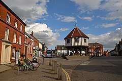 Wymondham Market Place in September 2017 | |
 Wymondham Wymondham shown within Norfolk | |
| Area | 44.31 km2 (17.11 sq mi) |
| Population | 14,405 (2011. Census)[1] |
| • Density | 325/km2 (840/sq mi) |
| OS grid reference | TG1101 |
| District | |
| Shire county | |
| Region | |
| Country | England |
| Sovereign state | United Kingdom |
| Post town | WYMONDHAM |
| Postcode district | NR18 |
| Dialling code | 01953 |
| Police | Norfolk |
| Fire | Norfolk |
| Ambulance | East of England |
| EU Parliament | East of England |
| UK Parliament | |
Wymondham (/ˈwɪndəm/ WIN-dəm) is a market town and civil parish in Norfolk, England, 9 1⁄2 miles (15 km) southwest of Norwich, just off the A11 road from Norwich to London which now bypasses the town.[2] The parish includes large rural areas to the north and south of the town itself, including the hamlets of Downham, Browick, Silfield, Wattlefield, Spooner Row and Suton.
History
Before the Great Fire
Moot Hill
The earthworks of what was probably a large, medieval ringwork survive to some considerable height; they have been subject to ground survey and are partially visible on aerial photographs. The ringwork, which is located in an isolated part of the Stanfield estate, is thought by some to have been built by the D'Albinis between 1088 and 1139. The feature measures approximately 150m by 130m, with a large bank and water-filled ditch; the internal area also appears to be filled with irregular water-filled pits or ponds. It is thought that a gold ring of Katherine Bigot, wife of Roger Fitz-Ortet who held Stanfield Manor in AD 1306, was also recovered from this area.
Wymondham's most famous inhabitant was Robert Kett (or Ket), who led a rebellion in 1549 of peasants and small farmers in protest at the enclosure of common land. He took a force of almost unarmed men and fought for and held the City of Norwich for six weeks until defeated by the King's forces. He was hanged from Norwich Castle. Kett's Oak, said to be the rallying point for the rebellion, can still be seen today on the B1172 road between Wymondham and Hethersett, part of the former main road to London.
The Great Fire of 1615

The Great Fire of Wymondham broke out on Sunday 11 June 1615. Two areas of the town were affected, implying there were two separate fires. One area was in Vicar Street and Middleton Street and the other in the Market Place, including Bridewell Street and Fairland Street. About 300 properties were destroyed in the fire. Important buildings destroyed included: the Market Cross, dating from 1286; the vicarage in Vicar Street; the 'Town Hall' on the corner of Middleton Street and Vicar Street; and the schoolhouse. However, many buildings such as the Green Dragon pub did survive and many of the houses in Damgate Street date back to 1400, although this is now masked by later brickwork.
The fire was blamed on three Romani – William Flodder, John Flodder and Ellen Pendleton (Flodder) – and a local person, Margaret Bix (Elvyn). The register of St Andrew's Church in Norwich records that John Flodder and others were executed on 2 December 1615 for the burning of Wymondham. Rebuilding of the destroyed buildings was quick in some cases and slower in others. A new Market Cross, extant 2016, was started and completed in 1617. However, by 1621 there were still about 15 properties not yet rebuilt. Economic conditions in the 1620s could have been a contributory factor to the delay in rebuilding.
After the Great Fire
Kett's Rebellion was evidence of an undercurrent of ferment in 16th-century Wymondham. Comparable discontent showed itself in the 17th century when a number of Wymondham citizens, including Thomas Lincoln, John Beal and others, moved to Hingham in the wave of religious dissent that swept England in the years preceding Cromwell's Commonwealth.
In 1785, a prison was built using the ideas of John Howard, the prison reformer. It was the first prison to be built in England with separate cells for the prisoners and was widely copied both in the United Kingdom and the United States.
The collapse of the woollen industry in the mid-19th century led to great poverty in Wymondham. In 1836 there were 600 hand looms, but by 1845 only 60 existed. During Victorian times the town was a backwater and never experienced large-scale development. The town centre remains very much as it must have been in the mid-17th century, when the houses were rebuilt after the Great Fire. These newer houses, and those which survived the Great Fire, still surround shoppers and visitors as they pass through Wymondham's narrow mediaeval streets.
Second World War
Wymondham played a part in the Second World War that is very poorly documented. It was home to one of MI6's Radio Security Service direction finding stations; the type at Wymondham was a "Spaced Loop" design newly developed by the National Physical Laboratory. Unfortunately, this was soon found to be unsatisfactory and was converted to the more traditional Adcock type. The station at Wymondham was located at 52°35′00″N 1°07′18″E / 52.583333°N 1.121667°E, just north of Tuttles Lane and east of Melton Road. Based on information from one of the wartime operators it transpires that another spaced loop station was later installed alongside the first in 1944 after the Normandy invasion. This may have been due to increased interest in transmissions from western Europe where the shorter distance made the spaced loop more reliable.
Recent history
Wymondham was struck by an F1/T2 tornado on 23 November 1981, as part of the record-breaking nationwide tornado outbreak on that day.[3]
Governance
The civil parish of Wymondham has an area of 44.31 km2 (17.11 sq mi) and in the 2001 census a population of 12,539, in 5,477 households, was recorded, rising to 14,405 at the 2011 Census. This relatively large parish includes one nearby village, Spooner Row.
Wymondham is governed by a town council of 15 councillors. The town is split into five wards, each of which returns three members. Since the last election (2015) and subsequent by-elections, 13 councillors are members of the Conservative Party, one is from the Liberal Democrats and one is from the Labour Party. The current mayor is Robert Savage.
For the purposes of local government, Wymondham civil parish falls within the district of South Norfolk, returning five district councillors, one for each ward. The town as a whole returns one county councillor to Norfolk County Council – Joseph Mooney.[4] Nationally, Wymondham is in the Mid Norfolk constituency and is therefore represented at Westminster by George Freeman.
Landmarks

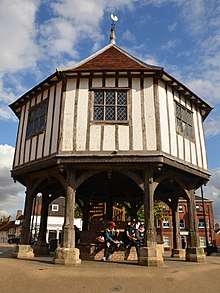
In the town centre, there is a market cross, which is now used as a Tourist Information Centre and is owned by the Town Council. The original building was destroyed in the Great Fire of Wymondham in 1615; the present building was rebuilt between 1617–18 at a cost of £25-7-0d with funds loaned by local man, Philip Cullyer.[5] The stilted building was like many others designed to protect valuable documents from both flood and vermin. According to T. F. Thistleton Dyer's English Folklore [London, 1878], live rats were nailed by their tails to the side of the building by way of a deterrent. This bizarre superstition ended in 1902 after a child was bitten, later to die of blood-poisoning.[6]
Wymondham Abbey is the Church of England parish church. Wymondham Manor became a Grade II listed building in 1953. The manor house, with a five-bay south front and a central Doric columned porch dates to the early 18th century, with later alterations and additions.[7] The headquarters of Norfolk Constabulary are located in Wymondham. The former town jail or bridewell now houses the Wymondham Heritage Museum.
Transport

The Wymondham railway station (voted Best Small Station in the 2006 National Rail Awards) possesses a piano showroom and a locally famous Brief Encounter-themed restaurant. The latter featured in Mark Greenstreet's 1996 comedy film Caught in the Act, which starred Sara Crowe, Annette Badland, Nadia Sawalha, Paul Shelly and Leslie Phillips. (N.B. Brief Encounter was shot 250 miles away, using Carnforth railway station, Lancashire.) The whole site has been restored by owner David Turner and also houses a small railway museum.
The station was featured as the "Walmington-on-Sea" station in the popular BBC comedy series Dad's Army. Wymondham station is the junction for the Mid-Norfolk Railway, although their trains, running 11.5 miles (19 km) north to Dereham operate from the separate Wymondham Abbey station. The town once had another station, Spinks Lane, but this closed shortly after opening in the 19th century.
Education

Robert Kett Primary School is a mixed primary school located in Wymondham.[8] named for the rebel Robert Kett. It is a state-funded[9] foundation school administered by Norfolk County Council. As of May 2015, the school has around 617 pupils around the ages of 4 to 11.[10][11][12][13][14]
Notable people
As of 2009, notable residents living in or close to Wymondham include/have included:
- Robert Kett, leader of Kett's Rebellion
- Francis Kett, Anglican martyr
- Harry Daniels, officer and VC recipient
- George Szirtes, poet
- W. G. Sebald, writer and academic
- Oliver Winterbottom, car designer
- Simon Beaufoy, writer of the films The Full Monty and Slumdog Millionaire
- Bill Bryson, humorist, author and travel writer
- Justin and Dan Hawkins of The Darkness
- Edwin Gooch, MP and President of the National Union of Agricultural and Allied Workers
- James Hubbard, the PDC Professional Darts player and former World Youth champion.
See also
References
- ↑ "Town population 2011". Retrieved 4 September 2015.
- ↑ Ordnance Survey (1999). OS Explorer Map 237 – Norwich. ISBN 0-319-21868-6.
- ↑ www.eswd.eu/cgi-bin/eswd.cgi
- ↑ Norfolk County Council
- ↑ "Wymondham Town History". Retrieved 28 August 2008.
- ↑ "'Wymondham Child Dies of Rat Bite' Eastern Daily Press, November 24th 1902". Archived from the original on 21 February 2009.
- ↑ "The Manor House, Wymondham". British Listed Buildings. Retrieved 28 September 2017.
- ↑ http://www.robertkett.norfolk.sch.uk/index.php/contact-us/
- ↑ http://www.robertkett.norfolk.sch.uk/index.php/school/governors/budget/
- ↑ "School Overview - Robert Kett Junior School : Directgov".
- ↑ "404 - Page not found". home.rm.com.
- ↑ "Robert Kett Junior School".
- ↑ "EduBase - Robert Kett Primary School".
- ↑ "School website for Robert Kett Junior School Wymondham with Ofsted inspection report".
External links
| Wikimedia Commons has media related to Wymondham. |
| Wikivoyage has a travel guide for Wymondham. |