Wyard Township, Foster County, North Dakota
| Wyard Township, North Dakota | |
|---|---|
| Township | |
 Wyard Township, North Dakota Location within the state of North Dakota | |
| Coordinates: 47°50′06″N 99°20′04″W / 47.83500°N 99.33444°WCoordinates: 47°50′06″N 99°20′04″W / 47.83500°N 99.33444°W | |
| Country | United States |
| State | North Dakota |
| County | Foster |
| Area | |
| • Total | 35.8 sq mi (93 km2) |
| • Land | 35.0 sq mi (91 km2) |
| • Water | 0.8 sq mi (2 km2) |
| Elevation | 1,581 ft (482 m) |
| Population (2000) | |
| • Total | 71 |
| • Density | 2/sq mi (0.8/km2) |
| Time zone | UTC-6 (Central (CST)) |
| • Summer (DST) | UTC-5 (CDT) |
| ZIP code | 58421 |
| Area code(s) | 701 |
| FIPS code | 38-87700[1] |
| GNIS feature ID | 1759431[2] |
Wyard Township is a township in Foster County, North Dakota, United States. It is known for the artificial lake Wyard Dam, used for recreational purposes, and unofficially known as the Kiwanis Dam.
References
- ↑ "American FactFinder". United States Census Bureau. Retrieved 2008-01-31.
- ↑ "US Board on Geographic Names". United States Geological Survey. 2007-10-25. Retrieved 2008-01-31.
External links
Municipalities and communities of Foster County, North Dakota, United States | ||
|---|---|---|
| Cities | 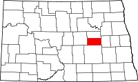 | |
| Townships |
| |
| Unincorporated communities | ||
This article is issued from
Wikipedia.
The text is licensed under Creative Commons - Attribution - Sharealike.
Additional terms may apply for the media files.