Melville, North Dakota
| Melville, North Dakota | |
|---|---|
| Unincorporated community | |
 Melville  Melville | |
| Coordinates: 47°20′05″N 99°02′08″W / 47.33472°N 99.03556°WCoordinates: 47°20′05″N 99°02′08″W / 47.33472°N 99.03556°W | |
| Country | United States |
| State | North Dakota |
| County | Foster |
| Elevation | 1,604 ft (489 m) |
| Time zone | UTC-6 (Central (CST)) |
| • Summer (DST) | UTC-5 (CDT) |
| Area code(s) | 701 |
| GNIS feature ID | 1030192[1] |
Melville is an unincorporated community in Foster County, North Dakota, United States. Melville is located along U.S. Route 52, U.S. Route 281 and the Red River Valley and Western Railroad 9 miles (14 km) south-southeast of Carrington.[2] Melville was originally named Newport after Northern Pacific Railway treasurer R. M. Newport; its name was changed to Melville for landowner Melville D. Carrington.[1]
References
- 1 2 "Melville". Geographic Names Information System. United States Geological Survey.
- ↑ Foster County, North Dakota General Highway Map (PDF) (Map). North Dakota Department of Transportation. 2004. Retrieved July 18, 2012.
Municipalities and communities of Foster County, North Dakota, United States | ||
|---|---|---|
| Cities | 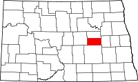 | |
| Townships |
| |
| Unincorporated communities | ||
This article is issued from
Wikipedia.
The text is licensed under Creative Commons - Attribution - Sharealike.
Additional terms may apply for the media files.