Wudinna, South Australia
| Wudinna South Australia | |||||||||
|---|---|---|---|---|---|---|---|---|---|
 | |||||||||
 Wudinna | |||||||||
| Coordinates | 33°02′S 135°27′E / 33.033°S 135.450°ECoordinates: 33°02′S 135°27′E / 33.033°S 135.450°E | ||||||||
| Population | 549 (2016 census)[1] | ||||||||
| Established | 1916 | ||||||||
| Postcode(s) | 5652[2] | ||||||||
| Elevation | 77 m (253 ft) | ||||||||
| Location | 570 km (354 mi) NW of Adelaide | ||||||||
| LGA(s) | Wudinna | ||||||||
| State electorate(s) | Flinders | ||||||||
| Federal Division(s) | Grey | ||||||||
| |||||||||
| Footnotes | Climate[3] | ||||||||
Wudinna is a town in South Australia. The area was first settled by Europeans in 1861 when Robert George Standley lodged a claim for 10 square miles (26 km2) of land surrounding Weedna Hill ('weedna' later became changed to Wudinna which may be an Aboriginal word meaning 'the granite hill'). It was proclaimed a town in 1916. It is on the Eyre Highway across the top of Eyre Peninsula. It is the seat of the Wudinna District Council.[4]
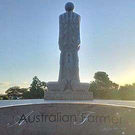
The region is known as The granite country for its deposits of granite in the area, with tourists able to travel the granite trail to explore local landmarks. Quarrying of granite has occurred in the local area since the 1990s. Some granite blocks quarried at the Desert Rose Quarry near Mount Wudinna can be up to 8 cubic metres in volume and weigh 20 tonnes, before being cut into smaller blocks for shipping around Australia, or for export to Asian and European markets. This granite was employed in the construction of The Australian Farmer, an 8-metre (26 ft) high statue that was carved in the town as a community project to commemorate the early settlers and provide something memorable for tourists.
Mount Wudinna is Australia's second largest monolith after Mount Augustus. It is located 12 kilometres (7 mi) north-east of the township. The site is listed on the South Australian Heritage Register.[5]
References
- ↑ Australian Bureau of Statistics (2017). Wudinna (Urban Centre/Locality). 2016 Census Quickstats. Retrieved on 2017-11-21
- ↑ Australia Post - Postcode Search
- ↑ "Monthly climate statistics: Summary statistics WUDINNA AERO (nearest weather station)". Commonwealth of Australia , Bureau of Meteorology. Retrieved 6 January 2017.
- ↑ "Contact". Wudinna District Council. Retrieved 14 February 2016.
- ↑ "Mount Wudinna & Environs (Mount Wudinna, Little Wudinna, Polda Rock and Turtle Rock) (designated place of geological significance)". South Australian Heritage Register. Department of Environment, Water and Natural Resources. Retrieved 12 February 2016.
External links
| Wikivoyage has a travel guide for Wudinna. |