Wrangell–Saint Elias Wilderness
| Wrangell-Saint Elias Wilderness | |
|---|---|
|
IUCN category Ib (wilderness area) | |
 | |
 | |
| Location | Wrangell-Saint Elias National Park and Preserve, Alaska, United States |
| Coordinates | 61°16′N 141°36′W / 61.267°N 141.600°WCoordinates: 61°16′N 141°36′W / 61.267°N 141.600°W |
| Area | 9,078,675 acres (36,740.09 km2) |
| Established | 1980 |
| Governing body | National Park Service |
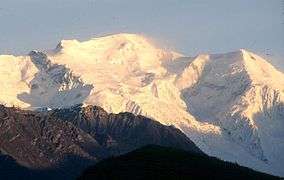
Wrangell–Saint Elias Wilderness is a wilderness area located in southwestern Alaska in the United States. At 9,078,675 acres (3,674,009 ha), the Wrangell–Saint Elias Wilderness is the largest designated U.S. Wilderness Area. The wilderness lies within Wrangell–St. Elias National Park and Preserve, the largest national park in the United States[1].
The wilderness contains the most extensive glaciation in Alaska (with more than 100 glaciers), nine of North America's 16 highest peaks (many over 16,000 feet), the 90-mile-long and 4,000-foot-thick Bagley Icefield (North America's largest subpolar ice field), and the Malaspina Glacier, which spreads 50 percent larger than the state of Delaware.
The wilderness area is part of the Kluane / Wrangell–St. Elias / Glacier Bay / Tatshenshini-Alsek international park system, a UNESCO World Heritage Site, located in Canada and the U.S.
The wilderness is home to many animals, including Dall sheep, grizzly bears, black bears, coyotes, bison, caribou, wolverines, moose, beavers, mountain goats, gray wolves, red foxes, and marmots.