Carbis
| Carbis | |
|---|---|
 Carbis Carbis shown within Cornwall | |
| OS grid reference | SW999595 |
| Civil parish | |
| Unitary authority | |
| Ceremonial county | |
| Region | |
| Country | England |
| Sovereign state | United Kingdom |
| Post town | ST. AUSTELL |
| Postcode district | PL26 |
| Dialling code | 01726 |
| EU Parliament | South West England |
| UK Parliament | |
Carbis is a hamlet 0.9 miles (1.4 km) east of Roche in Cornwall, England.[1] Carbis lies at about 495 feet (151 m) above sea level.[1]
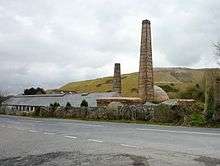
Old china clay works at Carbis
Rosemellyn China Clay works lies 0.4 miles (0.64 km) north-east of Carbis. In the 19th century the mining of china clay was an important industry around St Austell indeed the area has the nickname of the "china clay country". The Rosemellyn China Clay company went into liquidation in 1918. A short railway branch line (now dismantled) ran from Carbis Wharf to the sidings at nearby Bugle as part of the Cornwall Minerals Railway.[1]
References
- 1 2 3 "DEFRA Magic Map Application". DEFRA. Retrieved 10 January 2016.
Cornwall Portal | |
| Unitary authorities | |
| Major settlements |
|
| Rivers | |
| Topics | |
This article is issued from
Wikipedia.
The text is licensed under Creative Commons - Attribution - Sharealike.
Additional terms may apply for the media files.