Woodruff County Airport
| Woodruff County Airport | |||||||||||
|---|---|---|---|---|---|---|---|---|---|---|---|
 | |||||||||||
| Summary | |||||||||||
| Airport type | Public | ||||||||||
| Owner | Woodruff County | ||||||||||
| Serves | Woodruff County | ||||||||||
| Location | Augusta, Arkansas | ||||||||||
| Elevation AMSL | 200 ft / 61 m | ||||||||||
| Coordinates | 35°16′19″N 091°16′11″W / 35.27194°N 91.26972°WCoordinates: 35°16′19″N 091°16′11″W / 35.27194°N 91.26972°W | ||||||||||
| Runways | |||||||||||
| |||||||||||
| Statistics (2008) | |||||||||||
| |||||||||||
Woodruff County Airport (FAA LID: M60) is a county-owned public-use airport in Woodruff County, Arkansas, United States. It is located four nautical miles (5 mi, 7 km) east of the central business district of Augusta, Arkansas.[1]
This airport is included in the FAA's National Plan of Integrated Airport Systems for 2011–2015, which categorized it as a general aviation airport.[2]
Facilities and aircraft
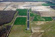
Woodruff County Airport covers an area of 100 acres (40 ha) at an elevation of 200 feet (61 m) above mean sea level. It has one runway designated 9/27 with an asphalt surface measuring 3,797 by 75 feet (1,157 x 23 m). For the 12-month period ending April 30, 2008, the airport had 5,500 general aviation aircraft operations, an average of 15 per day.[1]
References
- 1 2 3 FAA Airport Master Record for M60 (Form 5010 PDF). Federal Aviation Administration. effective 25 August 2011.
- ↑ "2011–2015 NPIAS Report, Appendix A (PDF, 2.03 MB)" (PDF). 2011–2015 National Plan of Integrated Airport Systems. Federal Aviation Administration. 4 October 2010.
External links
- Woodruff County Airport (M60) at Arkansas Department of Aeronautics
- Aerial image as of 6 March 2000 from USGS The National Map
- Resources for this airport:
- FAA airport information for M60
- AirNav airport information for M60
- FlightAware airport information and live flight tracker
- SkyVector aeronautical chart for M60
This article is issued from
Wikipedia.
The text is licensed under Creative Commons - Attribution - Sharealike.
Additional terms may apply for the media files.