Woodland Park, Nebraska
| Woodland Park, Nebraska | |
|---|---|
| Unincorporated community | |
 | |
 Woodland Park, Nebraska  Woodland Park, Nebraska | |
| Coordinates: 42°03′16″N 97°20′41″W / 42.05444°N 97.34472°WCoordinates: 42°03′16″N 97°20′41″W / 42.05444°N 97.34472°W | |
| Country | United States |
| State | Nebraska |
| County | Stanton |
| Area[1] | |
| • Total | 1.525 sq mi (3.95 km2) |
| • Land | 1.525 sq mi (3.95 km2) |
| • Water | 0 sq mi (0 km2) |
| Elevation | 1,693 ft (516 m) |
| Population (2010)[1] | |
| • Total | 1,866 |
| • Density | 1,200/sq mi (470/km2) |
| Time zone | UTC-6 (Central (CST)) |
| • Summer (DST) | UTC-5 (CDT) |
| Area code(s) | 402 & 531 |
| GNIS feature ID | 2587012[2] |
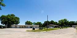
Woodland Park is an unincorporated community and census-designated place in Stanton County, Nebraska, United States. Its population was 1,866 as of the 2010 census.[1] Nebraska Highway 35 passes through the community.
Geography
According to the U.S. Census Bureau, the community has an area of 1.525 square miles (3.95 km2), all of it land.[1]
References
Municipalities and communities of Stanton County, Nebraska, United States | ||
|---|---|---|
| City | 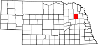 | |
| Village | ||
| CDP | ||
This article is issued from
Wikipedia.
The text is licensed under Creative Commons - Attribution - Sharealike.
Additional terms may apply for the media files.