Wonga Park, Victoria
| Wonga Park Melbourne, Victoria | |||||||||||||||
|---|---|---|---|---|---|---|---|---|---|---|---|---|---|---|---|
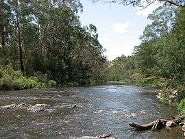 Yarra River, Wonga Park | |||||||||||||||
 Wonga Park | |||||||||||||||
| Coordinates | 37°44′20″S 145°16′01″E / 37.739°S 145.267°ECoordinates: 37°44′20″S 145°16′01″E / 37.739°S 145.267°E | ||||||||||||||
| Population | 3,796 (2016 census)[1] | ||||||||||||||
| • Density | 417.1/km2 (1,080/sq mi) | ||||||||||||||
| Postcode(s) | 3115 | ||||||||||||||
| Area | 9.1 km2 (3.5 sq mi) | ||||||||||||||
| Location | 29 km (18 mi) from Melbourne | ||||||||||||||
| LGA(s) | City of Manningham | ||||||||||||||
| State electorate(s) | |||||||||||||||
| Federal Division(s) | |||||||||||||||
| |||||||||||||||
Wonga Park is a locality within Greater Melbourne, beyond the Melbourne Metropolitan Urban Growth Boundary area,[2] 29 km north-east from Melbourne's Central Business District. Its local government area is the City of Manningham. At the 2011 census, Wonga Park had a population of 3,833.
Wonga Park is bounded in the west by Jumping Creek, in the north by the Yarra River, in the east by Brushy Park and Old Homestead Roads and in the south by Holloway Road.
The name comes from the Wonga Park grazing property, which itself derives from Simon Wonga, elder of the Wurundjeri indigenous people of Melbourne. The area was part of Mooroolbark until the 1890s.
History
In 1889 the Wonga Park property came into the hands of an insurance company and, along with other holdings, the land was sold by the Wonga Park Land Co. Four years later, when small settlements were a way of relieving unemployment after the failure of the land boom, about twenty members of an Eight Hours Pioneer Memorial Association took up small holdings on a former timber reserve.
In 1895 a primary school first opened, called Warrandyte East, but later changed to Wonga Park in 1898. The area was a mixture of orchards and grazing properties and timbered land. Most smaller properties had been started with income from firewood that came from clearing the land.
Eight Hour Pioneer Settlement Post Office opened in 1902, was renamed Wonga Park around 1907 and closed in 1989. It reopened in its current location in 1994.[3]
One of the grazing properties, Yarra Brae, was acquired by the Lord Clifford in 1942. He made part of it available for Australia's first Pan Pacific Scout Jamboree in 1948. Clifford Park hosted another Jamboree in 1955 and is now a major Scout campsite, available for use by non-Scouting organisations as well.[4]
In 1972 Yarra Brae was the site of a proposed Lower Yarra River Reservoir, but residents of the nearby Bend of Isles bushland estate persuaded the Victorian Government to abandon the proposal. The allied Sugarloaf Reservoir at Christmas Hills went ahead.
The residential development of Wonga Park came after the subdivisions in Croydon and Mooroolbark, which were on the Maroondah Highway and a railway line. Residential living is most concentrated around the old village settlement where the church, hall, sports facilities, fire station and local shops are found.
The northern boundary of Wonga Park, where land was acquired for the Yarra Brae storage, is a linear riverside part of the Warrandyte State Park. Wonga Park is also home to the largest residential block of land within metropolitan Melbourne, with many of the residential blocks being large in size, creating a private sanctuary for many of its residents. John Farnham resides in Wonga Park, as does V8 Supercar driver Garth Tander.
Shopping Village
Wonga Park shopping village used to have a number of shops including a newsagent, bakery, supermarket, hairdresser and fish & chip takeway. All the shops are now deserted.
Activities
Wonga Park has a tennis club, a cricket club, a golf course, a soccer club and numerous horse riding clubs. With the Yarra River being so close, canoeing is also a popular activity. The Clifford Park Scout Camp is also located in Wonga Park.
See also
- Shire of Lillydale - the former local government area of which Wonga Park was a part
References
- ↑ Australian Bureau of Statistics (31 October 2012). "Wonga Park (State Suburb)". 2011 Census QuickStats. Retrieved 2012-08-20.

- ↑ Urban Growth Boundary map
- ↑ Premier Postal History, Post Office List, retrieved 2008-04-11
- ↑ https://www.vicscouts.asn.au/CliffordPark/history.html