Wong Chuk Hang
| Wong Chuk Hang | |||||||||||||||||
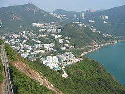 A view of residential Wong Chuk Hang from the Ocean Park cable car system | |||||||||||||||||
| Chinese | 黃竹坑 | ||||||||||||||||
|---|---|---|---|---|---|---|---|---|---|---|---|---|---|---|---|---|---|
| Cantonese Yale | Wòhngjūkhāang | ||||||||||||||||
| Literal meaning | "Yellow Bamboo Pit" | ||||||||||||||||
| |||||||||||||||||
Wong Chuk Hang (Cantonese pronunciation: [wɔ̏ːŋ tsók̚ háːŋ]) or Staunton Creek is an industrial and residential area in the Southern District of Hong Kong Island, in Hong Kong.
It is east of Aberdeen, north of Nam Long Shan, and west of Shouson Hill.[1]
History
A region called Chung Hom Wan, which is not far from Wong Chuk Hang, has unearthed Neolithic artifacts.[2]
Economy
The fashion company I.T has its head office on the 31st floor of Tower A of Southmark (南滙廣場) in Wong Chuk Hang.[3]
Features
Features of Wong Chuk Hang include:
- Grantham Hospital
- Holy Spirit Seminary
- Hong Kong Police Training School
- Ocean Park
- Wong Chuk Hang Estate
Climate
| Climate data for Wong Chuk Hang (1990–2016) | |||||||||||||
|---|---|---|---|---|---|---|---|---|---|---|---|---|---|
| Month | Jan | Feb | Mar | Apr | May | Jun | Jul | Aug | Sep | Oct | Nov | Dec | Year |
| Record high °C (°F) | 28.0 (82.4) |
28.5 (83.3) |
30.3 (86.5) |
30.9 (87.6) |
32.5 (90.5) |
35.3 (95.5) |
36.2 (97.2) |
36.0 (96.8) |
36.0 (96.8) |
33.4 (92.1) |
31.7 (89.1) |
29.4 (84.9) |
36.2 (97.2) |
| Average high °C (°F) | 19.5 (67.1) |
20.2 (68.4) |
22.3 (72.1) |
25.3 (77.5) |
28.3 (82.9) |
29.8 (85.6) |
30.7 (87.3) |
30.8 (87.4) |
30.3 (86.5) |
28.2 (82.8) |
25.2 (77.4) |
21.4 (70.5) |
26.0 (78.8) |
| Daily mean °C (°F) | 16.4 (61.5) |
17.3 (63.1) |
19.6 (67.3) |
22.9 (73.2) |
25.9 (78.6) |
27.7 (81.9) |
28.3 (82.9) |
28.2 (82.8) |
27.5 (81.5) |
25.3 (77.5) |
22.0 (71.6) |
18.1 (64.6) |
23.3 (73.9) |
| Average low °C (°F) | 13.8 (56.8) |
14.9 (58.8) |
17.3 (63.1) |
20.8 (69.4) |
23.9 (75) |
25.9 (78.6) |
26.2 (79.2) |
26.0 (78.8) |
25.3 (77.5) |
23.0 (73.4) |
19.5 (67.1) |
15.4 (59.7) |
21.0 (69.8) |
| Record low °C (°F) | 3.4 (38.1) |
7.0 (44.6) |
9.0 (48.2) |
10.9 (51.6) |
16.1 (61) |
20.8 (69.4) |
22.6 (72.7) |
22.5 (72.5) |
18.7 (65.7) |
16.3 (61.3) |
9.6 (49.3) |
4.7 (40.5) |
3.4 (38.1) |
| Average precipitation mm (inches) | 33.7 (1.327) |
25.5 (1.004) |
75.8 (2.984) |
162.9 (6.413) |
300.5 (11.831) |
472.9 (18.618) |
359.3 (14.146) |
396.3 (15.602) |
327.9 (12.909) |
85.9 (3.382) |
41.4 (1.63) |
29.6 (1.165) |
2,311.7 (91.012) |
| Average rainy days (≥ 0.5 mm) | 3.8 | 5.5 | 7.1 | 9.7 | 13.2 | 18.0 | 16.4 | 14.5 | 12.7 | 6.8 | 4.4 | 4.8 | 116.9 |
| Average relative humidity (%) | 71 | 76 | 79 | 83 | 84 | 85 | 83 | 83 | 78 | 71 | 70 | 67 | 77 |
| Source: Hong Kong Observatory[4] | |||||||||||||
Transport [5]

- Rail
Wong Chuk Hang Station, a station of the MTR South Island Line.
- Buses
Buses connecting Wong Chuk Hang and the Central and Western District:
- 70: from Central to Wah Kwai via Aberdeen Tunnel
- 71: from Central to Wong Chuk Hang via Pok Fu Lam
- 75: from Central to Wong Chuk Hang via Aberdeen Tunnel
- 90: from Central to Ap Lei Chau Estate (on Ap Lei Chau) via Aberdeen Tunnel
- 97: from Central to Lei Tung Estate (on Ap Lei Chau) via Aberdeen Tunnel
- 590: express service from Central to South Horizons (in Ap Lei Chau) via Aberdeen Tunnel
Buses connecting Wong Chuk Hang and the Eastern District:
- 41A: from North Point to Wah Fu Estate (in Wah Fu)
- 42: from North Point to Wah Fu Estate (in Wah Fu)
- 72: from Causeway Bay to Wah Kwai Estate (in Wah Fu)
- 76: from Causeway Bay to Shek Pai Wan Estate (in Aberdeen)
- 77: from Shau Kei Wan to Tin Wan Estate (in Tin Wan)
- 96: from Causeway Bay to Lei Tung Estate
- 99: from Shau Kei Wan to South Horizons
- 592: from Causeway Bay to South Horizons
Buses connecting Wong Chuk Hang and nearby towns
- 48: from Wah Fu Estate to Shum Wan/ Ocean Park
- 73: from Stanley to Cyberport
- 78: from Wah Kwai Estate to Wong Chuk Hang Station
- 97A: from Ap Lei Chau Main Street/ Lei Tung to Shum Wan
Buses connecting Wong Chuk Hang and Kowloon
- 107: from Wah Kwai Estate to Kowloon Bay
- 170: from Wah Fu Estate to Shatin
- 171: from South Horizons to Lai Chi Kok
- 671: from Ap Lei Chau to Diamond Hill
- 973: From Stanley to Tsim Sha Tsui
There are also a few minibuses connecting Wong Chuk Hang and different parts of Hong Kong.
See also
References
- ↑ https://maps.google.com/
- ↑ Reference: Hong Kong Archaeological Society website
- ↑ "I.T Limited Annual Report 16/17." Retrieved on 6 June 2018. p. 15 (PDF p. 11/114): "Registered Office Clarendon House 2 Church Street Hamilton HM11 Bermuda" and "Head Office and Principal Place of Business in Hong Kong 31/F., Tower A, Southmark 11 Yip Hing Street Wong Chuk Hang Hong Kong" - Chinese address, from p. 15 (PDF p. 11/115): "香港總辦事處及主要營業地點 香港黃竹坑業興街11號南滙廣場A座31樓"
- ↑ "Monthly Means of Meteorological Elements for Wong Chuk Hang, 1990-2016". Hong Kong Observatory. Retrieved February 8, 2017.
- ↑ http://www.nwfb.com.hk/
| Wikimedia Commons has media related to Wong Chuk Hang. |
Coordinates: 22°14′53″N 114°10′04″E / 22.24818°N 114.16765°E