Winterstown, Pennsylvania
| Winterstown, Pennsylvania | |
|---|---|
| Borough | |
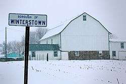 Snowy landscape at the northern end of Main Street | |
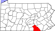
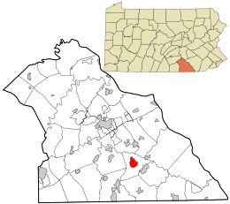 Location in York County and the U.S. state of Pennsylvania. | |
 Winterstown Location of Winterstown in Pennsylvania  Winterstown Winterstown (the US) | |
| Coordinates: 39°50′25″N 76°37′27″W / 39.84028°N 76.62417°WCoordinates: 39°50′25″N 76°37′27″W / 39.84028°N 76.62417°W | |
| Country | United States |
| State | Pennsylvania |
| County | York |
| Settled | 1830 |
| Incorporated | 1871 |
| Government | |
| • Type | Borough Council |
| Area[1] | |
| • Total | 2.41 sq mi (6.25 km2) |
| • Land | 2.41 sq mi (6.25 km2) |
| • Water | 0.00 sq mi (0.00 km2) |
| Elevation | 807 ft (246 m) |
| Population (2010) | |
| • Total | 632 |
| • Estimate (2016)[2] | 622 |
| • Density | 257.66/sq mi (99.48/km2) |
| Time zone | UTC-5 (Eastern (EST)) |
| • Summer (DST) | UTC-4 (EDT) |
| Area code(s) | 717 |
| FIPS code | 42-85872 |
Winterstown is a borough in York County, Pennsylvania, United States. The population was 632 at the 2010 census.[3]
Geography
Winterstown is located at 39°50′25″N 76°37′27″W / 39.84028°N 76.62417°W (39.840346, -76.624125).[4]
According to the United States Census Bureau, the borough has a total area of 2.3 square miles (6.0 km2), all of it land.
Demographics
| Historical population | |||
|---|---|---|---|
| Census | Pop. | %± | |
| 1880 | 199 | — | |
| 1890 | 209 | 5.0% | |
| 1900 | 217 | 3.8% | |
| 1910 | 238 | 9.7% | |
| 1920 | 222 | −6.7% | |
| 1930 | 219 | −1.4% | |
| 1940 | 265 | 21.0% | |
| 1950 | 298 | 12.5% | |
| 1960 | 349 | 17.1% | |
| 1970 | 424 | 21.5% | |
| 1980 | 491 | 15.8% | |
| 1990 | 581 | 18.3% | |
| 2000 | 546 | −6.0% | |
| 2010 | 632 | 15.8% | |
| Est. 2016 | 622 | [2] | −1.6% |
| Sources:[5][6][7] | |||
As of the census[6] of 2000, there were 546 people, 207 households, and 162 families residing in the borough. The population density was 234.1 people per square mile (90.5/km²). There were 215 housing units at an average density of 92.2 per square mile (35.6/km²). The racial makeup of the borough was 99.45% White, 0.18% African American, and 0.37% from two or more races.
There were 207 households out of which 33.8% had children under the age of 18 living with them, 66.2% were married couples living together, 7.7% had a female householder with no husband present, and 21.3% were non-families. 15.5% of all households were made up of individuals and 5.8% had someone living alone who was 65 years of age or older. The average household size was 2.64 and the average family size was 2.93.
In the borough the population was spread out with 23.4% under the age of 18, 7.0% from 18 to 24, 33.3% from 25 to 44, 25.1% from 45 to 64, and 11.2% who were 65 years of age or older. The median age was 37 years. For every 100 females there were 106.0 males. For every 100 females age 18 and over, there were 101.9 males.
The median income for a household in the borough was $45,625, and the median income for a family was $47,917. Males had a median income of $33,523 versus $23,583 for females. The per capita income for the borough was $19,934. About 3.6% of families and 4.6% of the population were below the poverty line, including 7.5% of those under age 18 and 9.5% of those age 65 or over.
References
- ↑ "2016 U.S. Gazetteer Files". United States Census Bureau. Retrieved Aug 14, 2017.
- 1 2 "Population and Housing Unit Estimates". Retrieved June 9, 2017.
- ↑ "Race, Hispanic or Latino, Age, and Housing Occupancy: 2010 Census Redistricting Data (Public Law 94-171) Summary File (QT-PL), Winterstown borough, Pennsylvania". U.S. Census Bureau, American FactFinder 2. Retrieved October 7, 2011.
- ↑ "US Gazetteer files: 2010, 2000, and 1990". United States Census Bureau. 2011-02-12. Retrieved 2011-04-23.
- ↑ "Census of Population and Housing". U.S. Census Bureau. Retrieved 11 December 2013.
- 1 2 "American FactFinder". United States Census Bureau. Retrieved 2008-01-31.
- ↑ "Incorporated Places and Minor Civil Divisions Datasets: Subcounty Resident Population Estimates: April 1, 2010 to July 1, 2012". Population Estimates. U.S. Census Bureau. Retrieved 11 December 2013.