Lower Chanceford Township, York County, Pennsylvania
| Lower Chanceford Township, Pennsylvania | |
|---|---|
| Township | |
 Oakland Run waterfalls as seen from the Mason-Dixon Trail | |
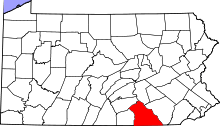
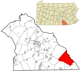 Location in York County and the state of Pennsylvania. | |
| Country | United States |
| State | Pennsylvania |
| County | York |
| Settled | 1734 |
| Incorporated | 1805 |
| Government | |
| • Type | Board of Supervisors |
| Area[1] | |
| • Total | 41.70 sq mi (108.00 km2) |
| • Land | 41.51 sq mi (107.50 km2) |
| • Water | 0.19 sq mi (0.50 km2) |
| Population (2010) | |
| • Total | 3,028 |
| • Estimate (2016)[2] | 3,076 |
| • Density | 74.11/sq mi (28.61/km2) |
| Time zone | UTC-5 (Eastern (EST)) |
| • Summer (DST) | UTC-4 (EDT) |
| Area code(s) | 717 |
| FIPS code | 42-133-44872 |
| Historical population | |||
|---|---|---|---|
| Census | Pop. | %± | |
| 2000 | 2,899 | — | |
| 2010 | 3,028 | 4.4% | |
| Est. 2016 | 3,076 | [2] | 1.6% |
| U.S. Decennial Census[3] | |||
Lower Chanceford Township is a township in York County, Pennsylvania, United States. The population was 3,028 at the 2010 census.[4]
History
The Muddy Creek Bridge, Maryland and Pennsylvania Railroad, Indian Steps Cabin, and McCalls Ferry Farm are listed on the National Register of Historic Places.[5]
Geography
According to the United States Census Bureau, the township has a total area of 41.7 square miles (108 km2), of which 41.6 square miles (108 km2) is land and 0.1 square miles (0.26 km2), or 0.34%, is water.
Demographics
As of the census[6] of 2000, there were 2,899 people, 1,028 households, and 793 families residing in the township. The population density was 69.7 people per square mile (26.9/km²). There were 1,169 housing units at an average density of 28.1/sq mi (10.8/km²). The racial makeup of the township was 97.93% White, 0.41% African American, 0.34% Native American, 0.55% Asian, 0.07% Pacific Islander, 0.31% from other races, and 0.38% from two or more races. Hispanic or Latino of any race were 0.41% of the population.
There were 1,028 households out of which 38.4% had children under the age of 18 living with them, 65.9% were married couples living together, 6.5% had a female householder with no husband present, and 22.8% were non-families. 19.3% of all households were made up of individuals and 6.8% had someone living alone who was 65 years of age or older. The average household size was 2.82 and the average family size was 3.24.
In the township the population was spread out with 30.0% under the age of 18, 7.4% from 18 to 24, 31.0% from 25 to 44, 22.3% from 45 to 64, and 9.2% who were 65 years of age or older. The median age was 35 years. For every 100 females, there were 104.4 males. For every 100 females age 18 and over, there were 103.0 males.
The median income for a household in the township was $43,081, and the median income for a family was $48,063. Males had a median income of $37,042 versus $21,890 for females. The per capita income for the township was $17,821. About 5.4% of families and 7.6% of the population were below the poverty line, including 12.0% of those under age 18 and 9.1% of those age 65 or over.
References
- ↑ "2016 U.S. Gazetteer Files". United States Census Bureau. Retrieved Aug 14, 2017.
- 1 2 "Population and Housing Unit Estimates". Retrieved June 9, 2017.
- ↑ "Census of Population and Housing". Census.gov. Retrieved June 4, 2016.
- ↑ "Race, Hispanic or Latino, Age, and Housing Occupancy: 2010 Census Redistricting Data (Public Law 94-171) Summary File (QT-PL), Lower Chanceford township, York County, Pennsylvania". U.S. Census Bureau, American FactFinder 2. Retrieved October 7, 2011.
- ↑ National Park Service (2010-07-09). "National Register Information System". National Register of Historic Places. National Park Service.
- ↑ "American FactFinder". United States Census Bureau. Retrieved 2008-01-31.
Coordinates: 39°48′00″N 76°20′59″W / 39.80000°N 76.34972°W