Winnisquam, New Hampshire
| Winnisquam, New Hampshire | |
|---|---|
| Unincorporated community | |
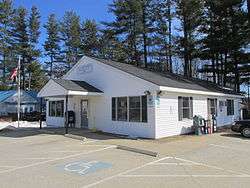 Winnisquam Post Office | |
 Winnisquam  Winnisquam | |
| Coordinates: 43°30′05″N 71°30′43″W / 43.50139°N 71.51194°WCoordinates: 43°30′05″N 71°30′43″W / 43.50139°N 71.51194°W | |
| Country | United States |
| State | New Hampshire |
| County | Belknap |
| Towns | Belmont, Sanbornton, Tilton |
| Elevation | 482 ft (147 m) |
| Time zone | UTC-5 (Eastern (EST)) |
| • Summer (DST) | UTC-4 (EDT) |
| ZIP code | 03289 |
| Area code(s) | 603 |
| GNIS feature ID | 870959[1] |
Winnisquam is an unincorporated community in the Lakes Region of New Hampshire, United States. The village is centered on the U.S. Route 3 bridge over the narrows of Winnisquam Lake and covers portions of three towns: Belmont, Sanbornton, and Tilton.
Winnisquam has a ZIP code of 03289, different from the ZIP codes in each of its component towns.
References
Municipalities and communities of Belknap County, New Hampshire, United States | ||
|---|---|---|
| City |  | |
| Towns | ||
| CDPs | ||
| Other villages | ||
| Footnotes | ‡This populated place also has portions in an adjacent county or counties | |
This article is issued from
Wikipedia.
The text is licensed under Creative Commons - Attribution - Sharealike.
Additional terms may apply for the media files.