Glendale, New Hampshire
| Glendale, New Hampshire | |
|---|---|
| Unincorporated community | |
 Location in New Hampshire | |
| Coordinates: 43°34′57″N 71°23′13″W / 43.58250°N 71.38694°WCoordinates: 43°34′57″N 71°23′13″W / 43.58250°N 71.38694°W | |
| Country | United States |
| State | New Hampshire |
| County | Belknap |
| Town | Gilford |
| Elevation | 548 ft (167 m) |
| Time zone | UTC-5 (Eastern (EST)) |
| • Summer (DST) | UTC-4 (EDT) |
| Area code(s) | 603 |
| GNIS feature ID | 871182[1] |
Glendale is an unincorporated community in the town of Gilford in Belknap County, New Hampshire, United States. Glendale is located on the southern shore of Lake Winnipesaukee east of Laconia. Glendale is served by New Hampshire Route 11 and is near Laconia Municipal Airport.
References
Municipalities and communities of Belknap County, New Hampshire, United States | ||
|---|---|---|
| City | 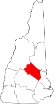 | |
| Towns | ||
| CDPs | ||
| Other villages | ||
| Footnotes | ‡This populated place also has portions in an adjacent county or counties | |
This article is issued from
Wikipedia.
The text is licensed under Creative Commons - Attribution - Sharealike.
Additional terms may apply for the media files.