Winklern
| Winklern | ||
|---|---|---|
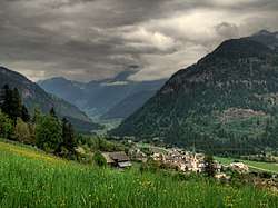 Winklern seen from the southwest | ||
| ||
 Winklern Location within Austria | ||
| Coordinates: 46°52′N 12°53′E / 46.867°N 12.883°ECoordinates: 46°52′N 12°53′E / 46.867°N 12.883°E | ||
| Country | Austria | |
| State | Carinthia | |
| District | Spittal an der Drau | |
| Government | ||
| • Mayor | Hermann Seebacher | |
| Area | ||
| • Total | 31.38 km2 (12.12 sq mi) | |
| Elevation | 966 m (3,169 ft) | |
| Population (1 January 2016)[1] | ||
| • Total | 1,211 | |
| • Density | 39/km2 (100/sq mi) | |
| Time zone | UTC+1 (CET) | |
| • Summer (DST) | UTC+2 (CEST) | |
| Postal code | 9841 | |
| Area code | 04822 | |
| Website | www.winklern.at | |

Winklern is a town in the district of Spittal an der Drau in the Austrian state of Carinthia.
Geography
The municipality lies at the foot of the Großglockner massif between the Schober, Goldberg, and Kreuzeck groups in the upper Möll valley.
References
This article is issued from
Wikipedia.
The text is licensed under Creative Commons - Attribution - Sharealike.
Additional terms may apply for the media files.