Wing, Rutland
| Wing | |
|---|---|
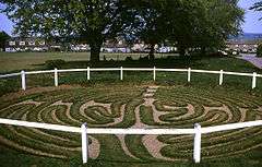 Wing's turf maze | |
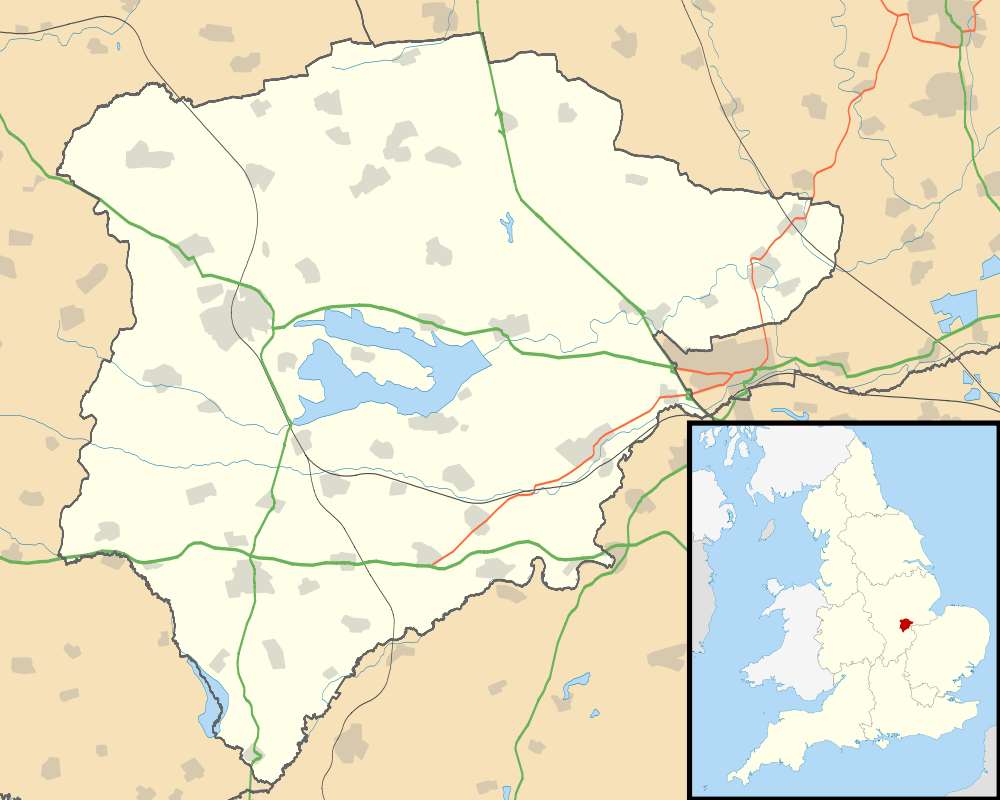 Wing Wing shown within Rutland | |
| Area | 1.74 sq mi (4.5 km2) [1] |
| Population | 315 2001 Census[2] |
| • Density | 181/sq mi (70/km2) |
| OS grid reference | SK893033 |
| • London | 80 mi (130 km) SSE |
| Unitary authority | |
| Shire county | |
| Ceremonial county | |
| Region | |
| Country | England |
| Sovereign state | United Kingdom |
| Post town | OAKHAM |
| Postcode district | LE15 |
| Dialling code | 01572 |
| Police | Leicestershire |
| Fire | Leicestershire |
| Ambulance | East Midlands |
| EU Parliament | East Midlands |
| UK Parliament | |
Wing is a small village and civil parish in the county of Rutland in the East Midlands of England. The population at the 2001 census was 315, reducing marginally to 314 at the 2011 census.[3]
Etymology
Its name first occurs as Wenge in the 12th century, and probably came from Old Norse vengi = "field".
Buildings and structures
The 17th-century houses in Wing were built from stone quarried at nearby Barnack and Clipsham. Many are roofed with Collyweston stone slate.[4]
The church, dedicated to Saint Peter and Saint Paul,[5] was much rebuilt in 1875, at which time the spire was removed. Some parts of the building date from Norman times, including the south arcade of about 1150, the slightly later north arcade and the north doorway.[6]

The remaining public house is the King's Arms. The Cuckoo Inn closed in 2004. Its name alluded to a local legend that the people of Wing once tried to keep spring in the village forever by erecting a fence around a cuckoo to stop it from leaving. Naturally, it flew over the fence and away. As a result, people from the village were known as "Wing Fools".[4] This is actually a widespread story, the best-known version probably being one of the adventures of the Wise Men of Gotham. There is a village hall.[7]
Wing Hall has a camping and caravan site with a shop and café.
A treatment plant just outside the village treats water extracted from Rutland Water reservoir a few miles to the north. Proposals by Anglian Water to extend the works, and increase the volume of drinking water extracted from the lake, were strongly opposed by the RSPB on the grounds that fluctuating water levels could potentially damage wildfowl habitats around the lake.[8]
Turf maze
Beside Glaston Road, cut in the turf by the roadside, is a circular "turf maze" (actually a unicursal labyrinth, roughly 40 ft (12 m) in diameter), is said to date back to medieval times, based on the fact that its design is similar to the pavement maze in Chartres cathedral and other medieval examples.
Notable people
- Francis Meres (1565–1647), churchman and author, became rector of Wing in 1602.
- Sir Charles Vernon Boys, FRS (1855–1944), experimental physicist, was born in Wing.[9]
- Thomas Smith (1556?–1609), English judge
- Air Chief Marshal Sir Clive Loader, Leicestershire Police and Crime Commissioner, 2012–16.[10]
See also
References
- ↑ "A vision of Britain through time". University of Portsmouth. Retrieved 21 March 2009.
- ↑ "Rutland Civil Parish Populations" (PDF). Rutland County Council. 2001. Retrieved 21 March 2009.
- ↑ "Civil Parish population 2011". Neighbourhood Statistics. Office for National Statistics. Retrieved 26 June 2016.
- 1 2 Leicestershire & Rutland Federation of Women's Institutes, ed. (1989). The Leicestershire & Rutland Village Book. Newbury: Countryside Books. ISBN 978-1-85306-056-4. Retrieved 11 March 2007.
- ↑ "Rutland Water Benefice - Wing". Retrieved 26 June 2016.
- ↑ Pevsner, Nikolaus, The Buildings of England - Leicestershire and Rutland
- ↑ "The Village Hall". 27 September 2015. Retrieved 26 June 2016.
- ↑ "RSPB Central England: Wing water treatment works". RSPB. Archived from the original on 30 September 2007. Retrieved 11 March 2007.
- ↑ McCarthy, G.J. (28 June 2005). "Boys, Charles Vernon (1855 - 1944)". Bright Sparcs. The University of Melbourne eScholarship Research Centre. Retrieved 22 March 2009.
- ↑ "Sir Clive Loader is ready to start new police role". Retrieved 26 June 2016.
External links
![]()
- Wing Community Website
- W. H. Matthews, Mazes and Labyrinths (1922) online version of W. H. Matthews classic book
- Labyrinthos Jeff Saward's website