Rutland Water
| Rutland Water | |
|---|---|
 | |
| Location | Rutland |
| Coordinates | 52°40′N 0°40′W / 52.667°N 0.667°WCoordinates: 52°40′N 0°40′W / 52.667°N 0.667°W |
| Lake type | reservoir |
| Basin countries | England |
| Managing agency | Anglian Water |
| Designation | Site of Special Scientific Interest |
| Built | 1971-1975 |
| First flooded | 1976 |
| Surface area | 10.86 square kilometres (4.19 sq mi) |
| Water volume | 124 million cubic metres (4.4×10⁹ cu ft) |
| Designated | 14 October 1991 |
| Reference no. | 533[1] |
.jpg)
Rutland Water is Anglian Water's drinking water reservoir in the county of Rutland, England, to the east of the county town, Oakham. It was known as Empingham Reservoir during its construction and until its official opening in 1976. The centre of its dam is at British national grid reference SK942078. It is filled by pumping water from the River Nene and River Welland and provides water to the East Midlands region of the United Kingdom. It is one of the largest artificial lakes in Europe. By surface area it is the largest reservoir in England, but by capacity it is exceeded by Kielder Water.
Set in 3,100 acres (13 km2) of countryside, it has a 23-mile (37 km) perimeter track (17-mile (27 km) excluding Hambleton Peninsula) for walking or cycling.[2] Since the water is drawn upon when needed, the relative areas of land and water vary a little but the flatter parts of the lake margin are enclosed by banks so that the wetland nature reserve is maintained (grid reference SK886073).
A 1,555 hectare area of lake and shore is a biological Site of Special Scientific Interest,[3][4] a Special Protection Area under the European Union Directive on the Conservation of Wild Birds[5] and Nature Conservation Review site.[6] An area of 1,333 hectares is a Ramsar internationally important wetland site,[7] and 393 hectares at the western end is managed by the Leicestershire and Rutland Wildlife Trust.[8]
Construction
Its construction by damming the Gwash valley near Empingham was completed in 1975. It flooded six or seven square kilometres of the Gwash valley as well as the side valley at the head of which lies Oakham. Nether Hambleton and most of Middle Hambleton were demolished and their wells were plugged as part of the ground preparation. Their neighbouring village of Upper Hambleton survived, and now sits on the Hambleton Peninsula. The Gwash makes a net input to the lake but its flow downstream is maintained. Most of the stored water is extracted from the River Welland at grid reference TF017060, between Tinwell and Stamford and from the River Nene upstream from Peterborough, a city which is a major user of the water.
Because much of the valley is clay, material for the dam was extracted from pits dug within the area that would be subsequently flooded. The clay dam is 115 feet (35 m) high, and around 1,300 yards (1,200 m) long. At its base, it is up to 890 yards (810 m) wide, and the finished structure has been landscaped to blend in with the environment, even when viewed from Empingham, the nearest village.[9]
Community
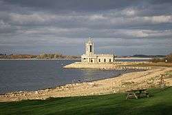
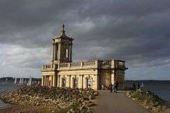
Upper Hambleton and the remnant of Middle Hambleton, including the Old Hall, are now known simply as Hambleton and are to be found on a long peninsula in the middle of the lake; land which was formerly a ridge between the two valleys in which the lake now lies. The few houses of Normanton avoided flooding although its church did not. The lower part of the building was supported against water damage so that its upper part could be used to present the story of the construction of the reservoir to the public. Some funerary monuments from it can be seen at Edenham church, Lincolnshire.
Recreation
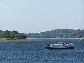
The reservoir is used not just for water storage, but is a popular sports centre – as well as water sports such as sailing[10] visitors enjoy fishing, walking and cycling along a 25 miles (40 km) perimeter track. A pleasure cruiser, the Rutland Belle, carries people around the lake. Birdwatching brings visitors from far afield. The former butterfly centre at Sykes Lane has been turned into Bugtopia – The Zoo.
Wildlife
Large areas of wetland (as well as several small woods) at the western end of the lake form a nature reserve, managed by Leicestershire and Rutland Wildlife Trust. The area is designated a Special Protection Area of international importance for its wintering populations of gadwall (some 4% of this species’ European population) and shoveller. It is home to the Anglian Water Bird Watching Centre. Every August, the centre is the venue for the British Birdwatching Fair. Other birds found here include lapwing, coot, goldeneye, tufted duck, pochard, teal, wigeon, cormorant, great crested grebe, little grebe and, most notably, osprey, which were re-introduced to the area during 1996,[11] including one called "Mr Rutland".
The lake is stocked with brown trout and rainbow trout, but there is a large head of coarse fish populated by water pumped in from the River Welland and River Nene, species include roach, bream, pike, zander, perch, eel, wels catfish and carp.
Visitor centres
The Anglian Water Birdwatching Centre, located in Egleton, features a gift shop operated by the Leicestershire and Rutland Wildlife Trust and a shop selling binoculars and telescopes. The centre includes the Rutland Environmental Education Centre, exhibits, and windows overlooking the wetlands.
The Lyndon Visitor Centre is located on the reserve's south shore. There are exhibits, bird viewing windows, trails and hides.
References
- ↑ "Rutland Water". Ramsar Sites Information Service. Retrieved 25 April 2018.
- ↑ Rutland Cycling. Cycle Map Rutland Water (Map).
- ↑ "Designated Sites View: Rutland Water". Sites of Special Scientific Interest. Natural England. Retrieved 13 September 2017.
- ↑ "Map of Rutland Water". Sites of Special Scientific Interest. Natural England. Retrieved 13 September 2017.
- ↑ "Designated Sites View: Rutland Water". Special Protection Area. Natural England. Retrieved 11 August 2017.
- ↑ "Rutland Water citation" (PDF). Sites of Special Scientific Interest. Natural England. Retrieved 11 August 2017.
- ↑ "Designated Sites View: Rutland Water". Ramsar Site. Natural England. Retrieved 11 August 2017.
- ↑ "Rutland Water". Leicestershire and Rutland Wildlife Trust. Retrieved 11 August 2017.
- ↑ "The Heritage of Rutland Water" (PDF). Rutland Local History & Record Society. p. 5. Archived from the original (PDF) on 19 March 2012. Retrieved 17 March 2011.
- ↑ "Rutland Sailing Club". Retrieved 28 October 2010.
- ↑ "Rutland Osprey Project". Retrieved 2012-03-06.
External links
| Wikimedia Commons has media related to Rutland Water. |