Wimer Bridge
|
Wimer Bridge | |
|
Formerly listed on the U.S. National Register of Historic Places | |
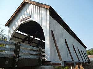 The 2008 version of the bridge | |
 Location of the bridge in Jackson County  Wimer Bridge (the US) | |
| Coordinates | 42°32′17.3″N 123°08′59.3″W / 42.538139°N 123.149806°WCoordinates: 42°32′17.3″N 123°08′59.3″W / 42.538139°N 123.149806°W |
|---|---|
| Built | 1927 (1892) (2008) |
| Built by | Hartman Brothers of Jacksonville (1927 version) |
| Architectural style | Queenpost truss (1927 version) |
| NRHP reference # | 79002075[1] |
| Significant dates | |
| Listed | November 29, 1979 |
| Removed from NRHP | after bridge collapse in 2003 |
The Wimer Bridge is a covered bridge over Evans Creek in Jackson County in the U.S. state of Oregon.[2] The version that was listed on the National Register of Historic Places, was built in 1927.[1] This structure, 85 feet (26 m) long, carried East Evans Creek County Road over the creek in the rural community of Wimer.[3] The creek is a tributary of the Rogue River, which it joins at the small city of Rogue River.[4]
An earlier covered span, built in 1892 by J. W. Osbourne, crossed the creek at this location, according to local residents and an engineering database.[2][5] The 1927 bridge replaced the older span.[2][5]
After the 1927 bridge deteriorated, local residents refurbished it in 1962. However, by the mid-1970s the bridge was closed after further decline. Repairs in 1985 led to reopening with an eight-ton limit, later reduced to three tons. Before further repairs were undertaken, the structure collapsed in 2003.[2] It fell 40 feet (12 m) into the water, injuring three people who were crossing the bridge.[6]
In 2008, with the help of federal funds and local labor, the bridge was replaced with a look-alike using trusses reinforced with metal braces, laminated beams that look like timber, concrete approaches, and industrial roofing made to resemble wooden shakes. The one-way bridge, still 17 feet (5.2 m) wide, as was the original, has a load limit of 10 tons.[6] This version of the bridge opened to traffic in February 2008.[5]
See also
References
- 1 2 "Oregon National Register List" (PDF). Oregon City County Management Association. November 10, 2005. p. 16. Retrieved February 17, 2016.
- 1 2 3 4 "Evans Creek (Wimer) Covered Bridge" (PDF). Oregon Department of Transportation. Retrieved February 17, 2016.
- ↑ Smith, Dwight A.; Norman, James B.; Dykman, Pieter T. (1989) [1986]. Historic Highway Bridges of Oregon (2nd ed.). Portland: Oregon Historical Society Press. p. 180. ISBN 0-87595-205-4.
- ↑ "United States Topographic Map". United States Geological Survey. Retrieved February 17, 2016 – via Acme Mapper.
- 1 2 3 "International Database for Civil and Structural Engineering: Wimer Bridge". Structurae. Retrieved February 17, 2016.
- 1 2 Mann, Damien (January 3, 2008). "Wimer Bridge Lives!". Medford Mail-Tribune. Local Media Group. Retrieved February 17, 2016.
External links
Trip Advisor: The Wimer Covered Bridge

| Lists by county |  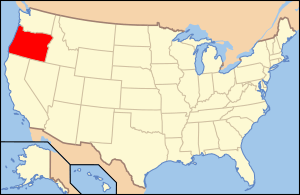 | |
|---|---|---|
| Portland lists | ||
| Other lists |
| |