Willow Hill Covered Bridge
| Willow Hill Covered Bridge | |
|---|---|
 | |
| Coordinates | 40°01′30″N 76°12′12″W / 40.0250°N 76.2033°WCoordinates: 40°01′30″N 76°12′12″W / 40.0250°N 76.2033°W |
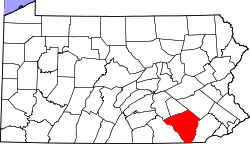
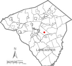
| Locale | Lancaster County, Pennsylvania, United States |
| Characteristics | |
| Design | single span, double Burr arch truss |
| Total length | 93 feet (28.3 m) |
| History | |
| Constructed by | Roy Zimmerman |
| Construction start | 1962 |
 | |
 | |
|
Landis Mill Covered Bridge | |
| Nearest city | Lancaster, Pennsylvania |
|---|---|
| Coordinates | 40°4′6″N 76°20′43″W / 40.06833°N 76.34528°W |
| Area | 0.1 acres (0.040 ha) |
| Built | 1878 |
| Architectural style | Other, King Post truss |
| MPS | Covered Bridges of Lancaster County TR |
| NRHP reference # | 80003526[1] |
| Added to NRHP | December 10, 1980 |
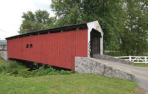
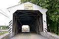
The Willow Hill Covered Bridge is a covered bridge located off U.S. Route 30 that spans Miller’s Run (which flows into Mill Creek, a tributary of the Conestoga River) in Lancaster County, Pennsylvania, United States. It was built in 1962 by Roy Zimmerman as a reconstruction using parts of the Miller's Farm Covered Bridge, built in 1871 by Elias McMellen, and Good's Fording Covered Bridge, built in 1855. It crosses Mill Creek and is 93 feet long and 15 feet wide.
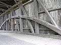
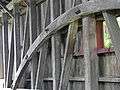
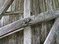
The bridge has a single span, wooden, double Burr arch trusses design with the addition of steel hanger rods. It is painted red, the traditional color of Lancaster County covered bridges, on the outside. The inside is unpainted. Both approaches to the bridge are painted in the traditional white color.
The bridge's WGCB Number is 38-36-43. Because it was constructed from two historic covered bridges, it is not listed on the National Register of Historic Places like most of the other covered bridges in the county. It is located at 40°1′30″N 76°12′11.9″W / 40.02500°N 76.203306°W.[2]
Dimensions
- Length: 93 feet (28.3 m) total length
- Width: 15 feet (4.6 m) total width
Gallery
See also
References
- Bickel, Hank (2005-06-23). "Willow Hill Bridge". Covered Bridges of the Northeast USA. Retrieved 2006-08-04.
- McCain, Dr. Roger A. "Willow Hill Bridge". A Guide to Old Covered Bridges of Southeastern Pennsylvania and nearby areas. Retrieved 2006-08-04.
- "Willow Hill Covered Bridge". Lancaster County Pennsylvania Dutch Country Official Visitors Center. Pennsylvania Dutch Convention & Visitors Bureau. 2006. Retrieved 2006-07-07.
- "The Covered Bridges of Lancaster County". Lancaster County, PA Government Portal. County of Lancaster, Pennsylvania. 2001-11-09. Retrieved 2006-07-07.
- ↑ National Park Service (2010-07-09). "National Register Information System". National Register of Historic Places. National Park Service.
- ↑ Travis, Dale. "38-36-43". Round Barns & Covered Bridges. Retrieved 2006-08-08.