William L. Whitehurst Field
| William L. Whitehurst Field | |||||||||||
|---|---|---|---|---|---|---|---|---|---|---|---|
 | |||||||||||
| Summary | |||||||||||
| Airport type | Public | ||||||||||
| Owner | Hardeman County | ||||||||||
| Serves | Bolivar, Tennessee | ||||||||||
| Elevation AMSL | 499 ft / 152 m | ||||||||||
| Coordinates | 35°12′52″N 089°02′36″W / 35.21444°N 89.04333°WCoordinates: 35°12′52″N 089°02′36″W / 35.21444°N 89.04333°W | ||||||||||
| Map | |||||||||||
 M08 Location of airport in Tennessee | |||||||||||
| Runways | |||||||||||
| |||||||||||
| Statistics (2013) | |||||||||||
| |||||||||||
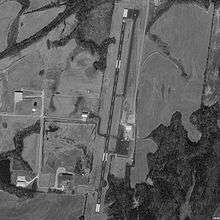
William L. Whitehurst Field (FAA LID: M08) is a county-owned, public-use airport located four nautical miles (7 km) southwest of the central business district of Bolivar, a city in Hardeman County, Tennessee, United States.[1]
Facilities and aircraft
William L. Whitehurst Field covers an area of 85 acres (34 ha) at an elevation of 499 feet (152 m) above mean sea level. It has one runway designated 1/19 with a 5,005 by 75 ft (1,526 by 23 m) asphalt surface. For the 12-month period ending June 1, 2013, the airport had 2,444 aircraft operations, an average of 47 per week: 89% transient general aviation; 10% local general aviation; <1% military ref: faa
The airport is attended from 0830 to 1700 local time and has 100LL aviation fuel and Jet-A available, plus 93 mogas (for approved aircraft). It is included under the McKellar-Sipes Regional Airport FSS. It has medium intensity runway lighting and PAPI on both runways. NOTAMs are filed with McKellar-Sipes Regional Airport.[2][3]
See also
References
- 1 2 FAA Airport Master Record for M08 (Form 5010 PDF), effective 2008-04-10
- ↑ Bolivar / William L. Whitehurst Fld (M08) at FAA Airport/Facility Directory, effective 2008-04-10
- ↑ Wm. L. Whitehurst Field - M08 at Tennessee DOT Airport Directory
External links
- Resources for this airport:
- FAA airport information for M08
- AirNav airport information for M08
- FlightAware airport information and live flight tracker
- SkyVector aeronautical chart for M08