Wildland–urban interface
A wildland–urban interface (or WUI) refers to the zone of transition between unoccupied land and human development. Communities that are within 0.5 miles (0.80 km) of the zone may also be included. These lands and communities adjacent to and surrounded by wildlands are at risk of wildfires.
Definitions
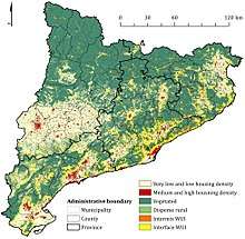
The US Forest Service defines the wildland-urban interface as the place where "homes and wildlands meet or intermingle", or more specifically, where "humans and their development meet or intermix with wildland fuel".[1] A more quantitative definition is provided by the Federal Register, which defines WUI areas as those containing at least one housing unit per 40 acres. Federal Register definitions can be combined with quantitative criteria to classify the WUI into two categories:
- Intermix WUI, or lands that contain at least one housing unit per 40 acres in which vegetation occupies at least 50% of terrestrial area, and
- Interface WUI, or lands that contain at least one housing unit per 40 acres, contain less than 50% vegetation, and lie within 2.4 km of a heavily vegetated area.
- A "heavily vegetated area" is defined as an area containing over 75% wildlife vegetation and occupies at least 5 km2 of terrestrial area.
The main difference between these types of WUI are that homes in intermix WUI are interspersed with vegetation, whereas homes in interface WUI are adjacent to heavy vegetation.[2]
WUI growth and causes
From 1990 to 2000, WUI area in the United States increased by 18 percent, covering 6 million additional homes. As of 2013, it was reported that the number of wildfires in the United States exceeding 50,000 acres had been steadily increasing since 1983, with the bulk of the change occurring from 2003 to 2013. The intensity of these fires was found to be increasing as well, contributing to an observed increase in costs related to reducing fire risks, fighting wildfires, and protecting property.[1] WUI growth has also been noted in other places throughout the world, including Argentina, France, South Africa, Australia, and Mediterranean regions.[3][4]
Population shifts
Factors behind WUI growth include population growth, housing growth in wildland areas, population shifts, and the expansion of cities into wildlands. In the United States, WUI growth is partially attributed to population shifts towards the West and South. Additionally, as of 2013, the migration of retiring baby-boomers to smaller communities closer to scenic natural resources (“amenity migration”) is expected to contribute to WUI growth as well.[1]
Between 1990 and 2010, the WUI was the fastest-growing land use type in the United States, and 97% of new WUI areas were the result of new housing rather than increases in wildlife vegetation.[4]
Ecological factors
Keane, et al. attribute the increase in WUI area to ecological factors such as climate change, insect pests, and diseases, which have resulted in more arid and flammable landscapes.[5] Climate change can result in significant shifts in wildlife composition due to changes in temperature and precipitation.[6] Population shifts can result in unintended ecological consequences resulting in higher landscape flammability. For example, flammable materials present in housing serve as a direct means of wildfire spread, while landscaping can cause non-native species to spread.[4]
To a small degree, vegetation growth into or near settled areas can lead to WUI growth. Between 1990 and 2010, vegetation growth accounted for 3% of all WUI growth in the United States.[4]
Impact on environment
Environmental issues related to WUI growth extend beyond the increased risk of wildfire damage to human settlements. For example, housing growth in WUI regions can displace and fragment native vegetation. Additionally, the introduction of non-native species by humans through landscaping can change the wildlife composition of interface regions.[4] Other factors can also have impacts on the environment, including pets which can kill large quantities of wildlife.[7]
Forest fragmentation is another impact of WUI growth, which can lead to unintended ecological consequences. For instance, increased forest fragmentation can lead to an increase in the prevalence of Lyme disease.[8] One possible reason for this effect is the production of high-density isolated populations of transmission vectors such as ticks and mice. Isolated forest patches in fragmented environments tend to be surrounded by unfavorable habitats, which hinders the dispersal of infected species and increases their local density. Additionally, disease vectors in isolated patches can undergo genetic differentiation, increasing their survivability as a whole.[9]
Increases in wildfire risk pose a threat to conservation in WUI growth regions. Between 1985-94 and 2005-14, the area burned by wildfires in the United States nearly doubled from 18,000 to 33,000 square kilometers, and this increase can partly be attributed to WUI growth.[4] In North America, Chile, and Australia, unnaturally high fire frequencies have resulted in incidences of exotic annual grasses replacing native shrublands.[3]
Wildfire Risk Assessment
As of 2013, 32 percent of homes, apartments, and other human dwellings in the United States are contained within the WUI, and this figure is expected to grow over time. Wildfires can pose a risk to any area containing vegetation, as embers transported by wind can ignite fires a mile or more away from a flame front.[1] The increase in wildfire prevalence in the United States between 1985-94 and 2005-14 resulted in a tripling of federal wildfire suppression expenditures from $0.4 billion per year to $1.4 billion per year, indicating that wildfires pose a potent economic risk to communities.[4]
Identification of high-risk areas
Geospatial quantification of wildfire risk can highlight key areas for policy and emergency response planning. Several factors are used to assess the threat wildfires pose to human settlements. These factors can mainly be divided into ecological factors (e.g. climate, seasonal weather patterns, and vegetation) and human factors (e.g. arrangement and density of housing). Quantitative risk assessments can be produced by combining data such as the probability of large wildfires, estimated wildfire intensity, population density, and the proximity of human settlements to roads. One approach, used by Haas et al., combines geographical data on population density and probability of exposure to a large wildfire to produce maps that highlight spatial variability in wildfire risk. The highest-risk areas identified by this method are those where moderate population levels overlap with or are adjacent to wildlands with high chances of wildfire exposure.[10]
Effect of population density on wildfire risk
Population density correlates with wildfire risk for two main reasons. First, people can cause fires; from 2001 to 2011, 85% of wildfires recorded by National Interagency Fire Center (NIFC) were caused by people. Second, housing can intensify wildfires because they can potentially contain highly flammable material such wood shakes, and can be a source for mobile embers which can cause wildfires to spread.[1]
The relationship between population density and wildfire risk is non-linear. At low population densities, human ignitions are low, and ignitions increase with population density. However, in a range of environments sampled from North America, the Mediterranean Basin, Chile, and South Africa, a threshold of population density was observed at which fire occurrence decreased. Possible reasons for this decrease include decreases in open space for ember transmission, fuel fragmentation due to urban development, and higher availability of fire-suppression resources. For this reason, areas with moderate population densities tend to exhibit higher wildfire risk than areas with low or high population densities.[3]
Wildfire simulation modeling
Some factors typically used in wildfire simulations include historical spatial wildfire data, geographic features, geographical distributions of vegetation, and climate.[6] One algorithm commonly used to simulate wildfire spread are Minimum Travel Time (MTT) algorithms.[10] Prior to MTT algorithms, fire boundaries were primarily modeled through the application of Huygens' principle by treating boundaries as wave fronts on a two-dimensional surface. MTT algorithms are capable of calculating fire perimeters in a nearly-equivalent way finding the minimum time it takes for a fire to travel between two points, and are advantageous due to their speed and scalability. However, MTT methods come at the cost of assuming nearly-constant environmental conditions such as wind direction and fuel moisture dynamics, and thus tend to be more apt for short-timescale simulations.[11]
Risk Management
The vulnerability of a community to wildfires is partly determined by its decisions regarding land use, building standards, and landscaping choices. Community-focused risk management efforts often focused on reducing the flammability of dwellings and wildland vegetation in and around high-risk areas.[1]
Distribution of responsibilities

Calkin, et al. present a conceptual framework for risk mitigation in the WUI. In this model, two major objectives that lead to decreased home loss are (a) reducing the probability of home exposure to wildfires and (b) reducing the susceptibility of houses to wildfire loss. The former can be split into three actionable objectives: reducing wildfire occurrence, reducing wildfire size and intensity, and reducing human development in fire-prone areas. The latter can be converted into a single actionable objective, i.e. increasing home resistance to ignition. In the framework, responsibility for actions is attributed to three major groups: land management agencies, local governments, and homeowners. Land management agencies can help reduce wildfire occurrence through ignition prevention, and can help reduce wildfire size and intensity through fuel and vegetation management, building community preparedness, and responding to wildfires with suppression efforts. Local governments can help reduce human development in fire-proof areas through proper land use management and zoning. Individual homeowners can also reduce the risk of home loss by taking action to manage the flammability of their homes.[12]
Community response
One approach to mitigating fire risk is adapting communities to adapt to fire risks rather than escalate prevention efforts. Fire-adapted communities are defined by the United States Forest Service as "a knowledgeable and engaged community in which the awareness and actions of residents regarding infrastructure, buildings, landscaping, and the surrounding ecosystem lessens the need for extensive protection actions and enables the community to safely accept fire as a part of the surrounding landscape." Fostering the development of a fire-adapted community can help save resources for local and federal governments by reducing the amount of resources needed for fire mitigation.[13]
Ways homeowners can reduce risk
The susceptibility of a home to ignition is determined by its home ignition zone (HIZ), or the home and its surrounding area up to 100-200 feet. Individual homeowners can use the following guidelines to determine what areas of their home can be improved to mitigate fire risk:[14]
- Ways to make a house fire-resistant:
- Ensure that the house's roof is made of fire-resistant materials and all exterior walls are fire resistant.
- Enclose eaves and vents with wire mesh.
- Ensure that decks and porches are made of fire-resistant materials.
- Guidelines for landscaping:
- Keep vegetation away from windows, as windows can break during a fire and let in embers.
- Ensure plants within 3-5 feet of the home are low-growing, well-maintained and deciduous.
- Keep bare dirt, mowed grass, or non-combustible mulch in a "no-grow" zone within 3-5 feet of the home.
- Limit the presence of evergreens (which are highly fammable) within 30 feet of the home.
- Keep vegetation thin within 30 to 100 feet of the home.
- Guidelines for outdoor maintenance:
- Trim back tree limbs at least 10 feet from roof.
- Ensure power lines are away from tree branches and nearby dead or dying trees.
- Clean off fallen leaves, pine needles, and other debris from roof, gutters, window wells, and underneath decks.
- Prune tree branches 6 feet up from ground (especially evergreens).
- Keep lawn mowed, green, and free of leaf litter and needles.
- Ensure yard is free of dead trees and shrubs.
- Ways to keep flammables at a safe distance:
- Ensure outbuildings within 30 feet of homes or other buildings are clear of flammables.
- Store firewood and other flammable materials at least 30 feet from buildings.
- Clear the area 10 feet surrounding propane tanks or fuel oil tanks.
Challenges to risk management
Wildfires are an ecological process that naturally contribute to the development of ecosystems, and many wildlands are historically predisposed to periodic fire. Because of this, complete eradication of fires in WUI regions is typically not feasible. Additionally, wildfires are capable of spreading through far distances, presenting logistical challenges to wildfire management efforts. At a governmental level, communities that have developed within or near fire-prone areas typically vary widely in terms of wildfire risk and preparedness, which can confound coordination efforts. Lastly, a mismatch between the reality of wildfire risk and sociopolitical expectations of wildland fire management services may lead to challenges to strategic risk management.[12]
See also
References
- 1 2 3 4 5 6 Stein, Susan M.; Comas, Sara J.; Menakis, James P.; Steward, Susan I.; Cleveland, Helene; Bramwell, Lincoln; Radeloff, Volker. "Wildfire, Wildlands, and People: Understanding and Preparing for Wildfire in the Wildland-Urban Interface" (PDF). USDA Forest Service. USDA. Retrieved 8 May 2018.
- ↑ Radeloff, V. C.; Hammer, R. B.; Stewart, S. I.; Fried, J. S.; Holcomb, S. S.; McKeefry, J. F. (2005). "The Wildland-Urban Interface in the United States" (PDF). Ecological Applications. 15 (3): 799–805. Retrieved 8 May 2018.
- 1 2 3 SYPHARD, ALEXANDRA D.; RADELOFF, VOLKER C.; HAWBAKER, TODD J.; STEWART, SUSAN I. (January 16, 2009). "Conservation Threats Due to Human-Caused Increases in Fire Frequency in Mediterranean-Climate Ecosystems". Conservation Biology. 23 (3): 758–769. doi:10.1111/j.1523-1739.2009.01223.x. ISSN 0888-8892.
- 1 2 3 4 5 6 7 Radeloff, Volker C.; Helmers, David P.; Kramer, H. Anu; Mockrin, Miranda H.; Alexandre, Patricia M.; Bar-Massada, Avi; Butsic, Van; Hawbaker, Todd J.; Martinuzzi, Sebastián (2018-03-27). "Rapid growth of the US wildland-urban interface raises wildfire risk". Proceedings of the National Academy of Sciences. 115 (13): 3314–3319. doi:10.1073/pnas.1718850115. PMC 5879688. PMID 29531054.
- ↑ Keane, Robert E.; Agee, James K.; Fulé, Peter; Keeley, Jon E.; Key, Carl; Kitchen, Stanley G.; Miller, Richard; Schulte, Lisa A. (2008). "Ecological effects of large fires on US landscapes: benefit or catastrophe?" (PDF). International Journal of Wildland Fire. 17: 696–712. Retrieved 8 May 2018.
- 1 2 Keane, Robert E.; Holsinger, Lisa M.; Parsons, Russell A.; Gray, Kathy (2008). "Climate change effects on historical range and variability of two large landscapes in western Montana, USA" (PDF). Forest Ecology and Management. 254: 375–389. Retrieved 8 May 2018.
- ↑ Loss, Scott R.; Will, Tom; Marra, Peter P. (2013-01-29). "The impact of free-ranging domestic cats on wildlife of the United States". Nature Communications. 4 (1). doi:10.1038/ncomms2380. ISSN 2041-1723.
- ↑ Brownstein, John S.; Skelly, David K.; Holford, Theodore R.; Fish, Durland (2005-09-27). "Forest fragmentation predicts local scale heterogeneity of Lyme disease risk". Oecologia. 146 (3): 469–475. doi:10.1007/s00442-005-0251-9. ISSN 0029-8549.
- ↑ Simon, Julie A.; Marrotte, Robby R.; Desrosiers, Nathalie; Fiset, Jessica; Gaitan, Jorge; Gonzalez, Andrew; Koffi, Jules K.; Lapointe, Francois-Joseph; Leighton, Patrick A. (2014-05-07). "Climate change and habitat fragmentation drive the occurrence ofBorrelia burgdorferi, the agent of Lyme disease, at the northeastern limit of its distribution". Evolutionary Applications. 7 (7): 750–764. doi:10.1111/eva.12165. ISSN 1752-4571. PMC 4227856. PMID 25469157.
- 1 2 Haas, Jessica R.; Calkin, David E.; Thompson, Matthew P. (2013). "A national approach for integrating wildfire simulation modeling into Wildland Urban Interface risk assessments within the United States" (PDF). Landscape and Urban Planning. 119: 44–53. doi:10.1016/j.landurbplan.2013.06.011. Retrieved 8 May 2018.
- ↑ Finney, Mark A (August 2002). "Fire growth using minimum travel time methods". Canadian Journal of Forest Research. 32 (8): 1420–1424. doi:10.1139/x02-068. ISSN 0045-5067.
- 1 2 Calkin, David E.; Cohen, Jack D.; Finney, Mark A.; Thompson, Matthew P. (2014-01-14). "How risk management can prevent future wildfire disasters in the wildland-urban interface". Proceedings of the National Academy of Sciences. 111 (2): 746–751. doi:10.1073/pnas.1315088111. PMC 3896199. PMID 24344292.
- ↑ "Frequently Asked Questions – Fire Adapted Communities" (PDF). USDA Forest Service Fire and Aviation Management. July 10, 2014. Archived from the original (PDF) on October 1, 2017. Retrieved June 6, 2018.
- ↑ "Home Ignition Zone Self Assessment for Homeowners" (PDF). Firewise Wisconsin. 2011. Archived from the original (PDF) on April 30, 2018. Retrieved June 6, 2018.