Whitman, Nebraska
| Whitman, Nebraska | |
|---|---|
| Unincorporated community | |
 | |
 Whitman Location within the state of Nebraska | |
| Coordinates: 42°2′31″N 101°31′24″W / 42.04194°N 101.52333°WCoordinates: 42°2′31″N 101°31′24″W / 42.04194°N 101.52333°W | |
| Country | United States |
| State | Nebraska |
| County | Grant |
| Elevation | 3,602 ft (1,098 m) |
| Time zone | UTC-7 (Mountain (MST)) |
| • Summer (DST) | UTC-6 (MDT) |
| ZIP code | 69366 |
| FIPS code | 31-52890 |
| GNIS feature ID | 834693 |
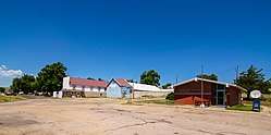
Whitman is an unincorporated community in northeastern Grant County, Nebraska, United States. It lies along Nebraska Highway 2 east of the village of Hyannis, the county seat of Grant County.[1] The University of Nebraska-Lincoln Gudmundsen Sandhills Laboratory lies just north of the community.[2] Although Whitman is unincorporated, it has a post office, with the ZIP code of 69366.[3]
History
Whitman was established in the 1860s when the railroad was extended to that point.[4] It was named after the town of Whitman, Massachusetts by a railroad official.[5][6]
References
- ↑ Rand McNally. The Road Atlas '08. Chicago: Rand McNally, 2008, p. 62.
- ↑ Gudmundsen Sandhills Laboratory
- ↑ Zip Code Lookup
- ↑ "Hyannis, Grant County". Center for Advanced Land Management Information Technologies. University of Nebraska. Retrieved 9 August 2014.
- ↑ Alan Boye (1 April 2007). The Complete Roadside Guide to Nebraska. U of Nebraska Press. p. 386. ISBN 0-8032-3378-7.
- ↑ Fitzpatrick, Lillian L. (1960). Nebraska Place-Names. University of Nebraska Press. p. 69. ISBN 0-8032-5060-6. A 1925 edition is available for download at University of Nebraska—Lincoln Digital Commons.
Municipalities and communities of Grant County, Nebraska, United States | ||
|---|---|---|
| Village | ||
| Unincorporated communities | ||
This article is issued from
Wikipedia.
The text is licensed under Creative Commons - Attribution - Sharealike.
Additional terms may apply for the media files.